Xikou geodata
Xikou (Zhejiang) is a seat of a fourth-order administrative division; located in China in Asia/Shanghai (GMT+8) time zone. In our database, there are 1268 cities with bigger population. Compared to other cities in China, 57.6% of cities are located further ↑North; 89% of cities are located further ←West and 79.8% of cities have higher elevation than Xikou. Note1


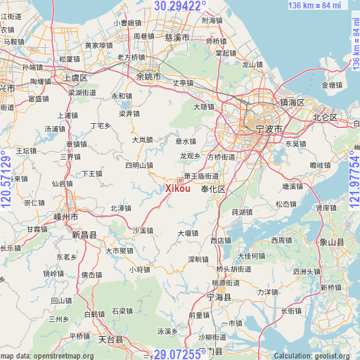
Xikou GPS coordinates[2]
29° 41' 6.864" North, 121° 16' 27.876" East
| Map corner | latitude | longitude |
|---|---|---|
| Upper-left | 30.29422°, | 120.57129° |
| Center: | 29.68524°, | 121.27441° |
| Lower-right: | 29.07255°, | 121.97754° |
| Map W x H: | 135.8×135.8 km | = 84.4×84.4mi |
| max Lat: | 53.31946° ⇑57.6% North |
| Xikou: | 29.68524° |
| min Lat: | ⇓42.4% South 18.22056° |
| min Long | Xikou | max Long |
| 75.07348° | 121.27441° | 134.28917° |
| W 89%⇐ | ⇒11% E |
Elevation
Elevation of Xikou is 27 m = 89 ft, and this is 457.8 m = 1502 ft below average elevation for this country.
| Max E: |
5622 m = 18445 ft | 79.8% |
| Avg. | 484.8 m = 1591 ft | |
| Xikou | 27 m = 89 ft | |
Min E: |
-3 m = -10 ft | 20.2% |
See also: China elevation on elevation.city.
Geographical zone
Xikou is located in North temperate zone (between Tropic of Cancer and the Arctic Circle). Distance of this Northern Tropic circle is 694.8 km =431.7 mi to South.| Distance of | km | miles | from Xikou |
|---|---|---|---|
| North Pole | 6706.4 | 4167.2 | to North |
| Arctic Circle | 4100.5 | 2547.9 | to North |
| Tropic Cancer | 694.8 | 431.7 | to South |
| Equator | 3300.7 | 2051 | to South |


Nearby cities:
15 places around Xikou: (largest is in red/bold)
• Beizhang
24.9 km =15.5 mi,  245°
245°
• Dayan
19.9 km =12.4 mi,  172°
172°
• Dongqiao
16.3 km =10.1 mi,  49°
49°
• Fenghua
13.2 km =8.2 mi,  104°
104°
• Hengjie
22.7 km =14.1 mi,  31°
31°
• Jiangkou
13.6 km =8.5 mi,  66°
66°
• Jinping
12.6 km =7.8 mi, 101°
• Maoshan
22.4 km =13.9 mi, 72°
• Shangtian
14.7 km =9.1 mi,  120°
120°
• Shaxi
23.6 km =14.7 mi,  216°
216°
• Simingshan
16.8 km =10.4 mi,  289°
289°
• Xiaowangmiao
8.1 km =5 mi,  77°
77°
• Xiwu
20.2 km =12.6 mi,  90°
90°
• Yinjiang
12.6 km =7.8 mi,  38°
38°
• Zhangshui
15.2 km =9.4 mi,  9°
9°
Sources, notices
• [Note1] Compared only with cities in China existing in our database
• [Src1] Map data: © OpenStreetMap contributors (CC-BY-SA)
• [Src2] Other city data from geonames.org with taken over terms of usage.
• [Src3] Geographical zone / Annual Mean Temperature by Robert A. Rohde @ Wikipedia
