Shangchewan geodata
Shangchewan (Hubei) is a seat of a fourth-order administrative division; located in China in Asia/Shanghai (GMT+8) time zone. In our database, there are 1268 cities with bigger population. Compared to other cities in China, 56.3% of cities are located further ↑North; 57.6% of cities are located further →East and 78.8% of cities have higher elevation than Shangchewan. Note1


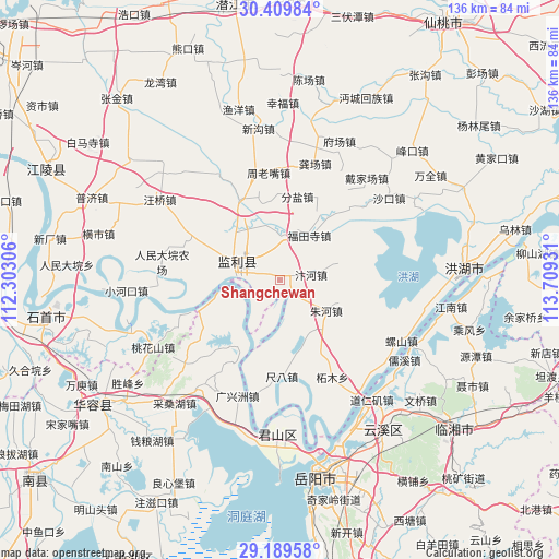
Shangchewan GPS coordinates[2]
29° 48' 5.652" North, 113° 0' 22.248" East
| Map corner | latitude | longitude |
|---|---|---|
| Upper-left | 30.40984°, | 112.30306° |
| Center: | 29.80157°, | 113.00618° |
| Lower-right: | 29.18958°, | 113.70931° |
| Map W x H: | 135.7×135.7 km | = 84.3×84.3mi |
| max Lat: | 53.31946° ⇑56.3% North |
| Shangchewan: | 29.80157° |
| min Lat: | ⇓43.7% South 18.22056° |
| min Long | Shangchewan | max Long |
| 75.07348° | 113.00618° | 134.28917° |
| W 42.4%⇐ | ⇒57.6% E |
Elevation
Elevation of Shangchewan is 29 m = 95 ft, and this is 455.8 m = 1495 ft below average elevation for this country.
| Max E: |
5622 m = 18445 ft | 78.8% |
| Avg. | 484.8 m = 1591 ft | |
| Shangchewan | 29 m = 95 ft | |
Min E: |
-3 m = -10 ft | 21.2% |
See also: China elevation on elevation.city.
Geographical zone
Shangchewan is located in North temperate zone (between Tropic of Cancer and the Arctic Circle). Distance of this Northern Tropic circle is 707.7 km =439.7 mi to South.| Distance of | km | miles | from Shangchewan |
|---|---|---|---|
| North Pole | 6693.4 | 4159.1 | to North |
| Arctic Circle | 4087.6 | 2539.9 | to North |
| Tropic Cancer | 707.7 | 439.7 | to South |
| Equator | 3313.6 | 2059 | to South |


Nearby cities:
15 places around Shangchewan: (largest is in red/bold)
• Bianhe
7.5 km =4.7 mi,  77°
77°
• Chiba
23.5 km =14.6 mi,  178°
178°
• Fenyan
20.7 km =12.9 mi,  11°
11°
• Futiansi
12.9 km =8 mi,  32°
32°
• Gongchang
29.4 km =18.3 mi,  17°
17°
• Hongcheng
12.2 km =7.6 mi,  292°
292°
• Maoshi
10.8 km =6.7 mi,  0°
0°
• Qiaoshi
19.5 km =12.1 mi,  122°
122°
• Qipan
15.2 km =9.4 mi,  112°
112°
• Qujiawan
25.5 km =15.8 mi,  43°
43°
• Sanzhou
28.7 km =17.8 mi,  192°
192°
• Zhemu
26.9 km =16.7 mi,  151°
151°
• Zhouhe
22.7 km =14.1 mi,  62°
62°
• Zhoulaozui
25.9 km =16.1 mi,  354°
354°
• Zhuhe
13.7 km =8.5 mi, 123°
Sources, notices
• [Note1] Compared only with cities in China existing in our database
• [Src1] Map data: © OpenStreetMap contributors (CC-BY-SA)
• [Src2] Other city data from geonames.org with taken over terms of usage.
• [Src3] Geographical zone / Annual Mean Temperature by Robert A. Rohde @ Wikipedia
