Shangcang geodata
Shangcang (Tianjin) is a populated place; located in China in Asia/Shanghai (GMT+8) time zone. With population of 1,312 people, there are 1121 cities with bigger population in this country. Compared to other cities in China, 86% of cities are located further ↓South; 68.3% of cities are located further ←West and 88.7% of cities have higher elevation than Shangcang. Note1


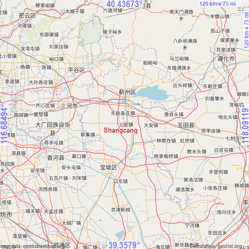
Shangcang GPS coordinates[2]
39° 53' 57.984" North, 117° 23' 17.016" East
| Map corner | latitude | longitude |
|---|---|---|
| Upper-left | 40.43673°, | 116.68494° |
| Center: | 39.89944°, | 117.38806° |
| Lower-right: | 39.3579°, | 118.09119° |
| Map W x H: | 120×120 km | = 74.6×74.6mi |
| max Lat: | 53.31946° ⇑14% North |
| Shangcang: | 39.89944° |
| min Lat: | ⇓86% South 18.22056° |
| min Long | Shangcang | max Long |
| 75.07348° | 117.38806° | 134.28917° |
| W 68.3%⇐ | ⇒31.7% E |
Elevation
Elevation of Shangcang is 11 m = 36 ft, and this is 473.8 m = 1554 ft below average elevation for this country.
| Max E: |
5622 m = 18445 ft | 88.7% |
| Avg. | 484.8 m = 1591 ft | |
| Shangcang | 11 m = 36 ft | |
Min E: |
-3 m = -10 ft | 11.3% |
See also: China elevation on elevation.city.
Geographical zone
Shangcang is located in North temperate zone (between Tropic of Cancer and the Arctic Circle). Distance of this Northern Tropic circle is 1830.5 km =1137.4 mi to South.| Distance of | km | miles | from Shangcang |
|---|---|---|---|
| North Pole | 5570.7 | 3461.5 | to North |
| Arctic Circle | 2964.8 | 1842.2 | to North |
| Tropic Cancer | 1830.5 | 1137.4 | to South |
| Equator | 4436.4 | 2756.7 | to South |


Nearby cities:
15 places around Shangcang: (largest is in red/bold)
• Dabao’anzhen
7.5 km =4.7 mi,  90°
90°
• Dahengshang
10.8 km =6.7 mi,  125°
125°
• Dayanggezhuang
9.5 km =5.9 mi,  161°
161°
• Dongshigu
5.4 km =3.4 mi,  245°
245°
• Dongtazhuang
4.4 km =2.7 mi,  261°
261°
• Dongzhaogezhuang
5.7 km =3.5 mi,  344°
344°
• Dong’erying
11.3 km =7 mi,  304°
304°
• Liuzikou
4.8 km =3 mi,  227°
227°
• Lizhuangzi
11.4 km =7.1 mi,  323°
323°
• Mengquan
11.2 km =7 mi,  137°
137°
• Sanchakou
14.1 km =8.8 mi,  204°
204°
• Xiacang
12.8 km =8 mi,  169°
169°
• Yangjinzhuang
1.8 km =1.1 mi,  152°
152°
• Yinliu
9.3 km =5.8 mi,  4°
4°
• Youguzhuang
12.1 km =7.5 mi,  273°
273°
Sources, notices
• [Note1] Compared only with cities in China existing in our database
• [Src1] Map data: © OpenStreetMap contributors (CC-BY-SA)
• [Src2] Other city data from geonames.org with taken over terms of usage.
• [Src3] Geographical zone / Annual Mean Temperature by Robert A. Rohde @ Wikipedia
