Sandun geodata
Sandun (Zhejiang) is a seat of a fourth-order administrative division; located in China in Asia/Shanghai (GMT+8) time zone. In our database, there are 1268 cities with bigger population. Compared to other cities in China, 51% of cities are located further ↑North; 82.4% of cities are located further ←West and 87.7% of cities have higher elevation than Sandun. Note1


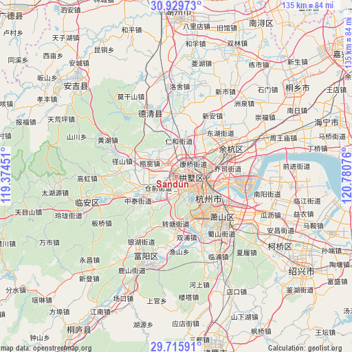
Sandun GPS coordinates[2]
30° 19' 28.92" North, 120° 4' 39.468" East
| Map corner | latitude | longitude |
|---|---|---|
| Upper-left | 30.92973°, | 119.37451° |
| Center: | 30.3247°, | 120.07763° |
| Lower-right: | 29.71591°, | 120.78076° |
| Map W x H: | 135×135 km | = 83.9×83.9mi |
| max Lat: | 53.31946° ⇑51% North |
| Sandun: | 30.3247° |
| min Lat: | ⇓49% South 18.22056° |
| min Long | Sandun | max Long |
| 75.07348° | 120.07763° | 134.28917° |
| W 82.4%⇐ | ⇒17.6% E |
Elevation
Elevation of Sandun is 12 m = 39 ft, and this is 472.8 m = 1551 ft below average elevation for this country.
| Max E: |
5622 m = 18445 ft | 87.7% |
| Avg. | 484.8 m = 1591 ft | |
| Sandun | 12 m = 39 ft | |
Min E: |
-3 m = -10 ft | 12.3% |
See also: China elevation on elevation.city.
Geographical zone
Sandun is located in North temperate zone (between Tropic of Cancer and the Arctic Circle). Distance of this Northern Tropic circle is 765.9 km =475.9 mi to South.| Distance of | km | miles | from Sandun |
|---|---|---|---|
| North Pole | 6635.3 | 4123 | to North |
| Arctic Circle | 4029.4 | 2503.8 | to North |
| Tropic Cancer | 765.9 | 475.9 | to South |
| Equator | 3371.8 | 2095.1 | to South |


Nearby cities:
15 places around Sandun: (largest is in red/bold)
• Banshan
10.1 km =6.3 mi,  72°
72°
• Cangqian
9.1 km =5.7 mi,  245°
245°
• Gongchenqiao
5.3 km =3.3 mi,  98°
98°
• Gudang
6.5 km =4 mi,  142°
142°
• Hangzhou
8.8 km =5.5 mi,  113°
113°
• Jiangcun
4.5 km =2.8 mi,  195°
195°
• Kangqiao
7.8 km =4.8 mi,  54°
54°
• Liangzhu
6.7 km =4.2 mi,  334°
334°
• Liuxia
9.1 km =5.7 mi, 195°
• Mishixiang
7.1 km =4.4 mi,  117°
117°
• Shangtang
7 km =4.3 mi, 98°
• Xiangfu
2.1 km =1.3 mi, 74°
• Xiaohe
5.7 km =3.5 mi, 106°
• Xihu
10 km =6.2 mi,  156°
156°
• Xindong
9.3 km =5.8 mi, 102°
Sources, notices
• [Note1] Compared only with cities in China existing in our database
• [Src1] Map data: © OpenStreetMap contributors (CC-BY-SA)
• [Src2] Other city data from geonames.org with taken over terms of usage.
• [Src3] Geographical zone / Annual Mean Temperature by Robert A. Rohde @ Wikipedia
