Sandouping geodata
Sandouping (Hubei) is a seat of a fourth-order administrative division; located in China in Asia/Shanghai (GMT+8) time zone. In our database, there are 1268 cities with bigger population. Compared to other cities in China, 53% of cities are located further ↓South; 66.9% of cities are located further →East and 62.1% of cities have higher elevation than Sandouping. Note1


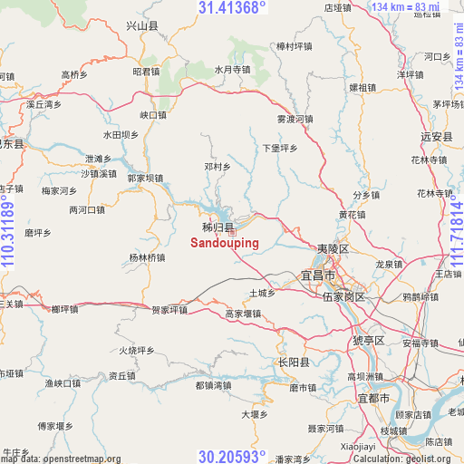
Sandouping GPS coordinates[2]
30° 48' 42.12" North, 111° 0' 54.036" East
| Map corner | latitude | longitude |
|---|---|---|
| Upper-left | 31.41368°, | 110.31189° |
| Center: | 30.8117°, | 111.01501° |
| Lower-right: | 30.20593°, | 111.71814° |
| Map W x H: | 134.3×134.3 km | = 83.5×83.5mi |
| max Lat: | 53.31946° ⇑47% North |
| Sandouping: | 30.8117° |
| min Lat: | ⇓53% South 18.22056° |
| min Long | Sandouping | max Long |
| 75.07348° | 111.01501° | 134.28917° |
| W 33.1%⇐ | ⇒66.9% E |
Elevation
Elevation of Sandouping is 87 m = 285 ft, and this is 397.8 m = 1305 ft below average elevation for this country.
| Max E: |
5622 m = 18445 ft | 62.1% |
| Avg. | 484.8 m = 1591 ft | |
| Sandouping | 87 m = 285 ft | |
Min E: |
-3 m = -10 ft | 37.9% |
See also: China elevation on elevation.city.
Geographical zone
Sandouping is located in North temperate zone (between Tropic of Cancer and the Arctic Circle). Distance of this Northern Tropic circle is 820 km =509.5 mi to South.| Distance of | km | miles | from Sandouping |
|---|---|---|---|
| North Pole | 6581.1 | 4089.3 | to North |
| Arctic Circle | 3975.2 | 2470.1 | to North |
| Tropic Cancer | 820 | 509.5 | to South |
| Equator | 3425.9 | 2128.8 | to South |


Nearby cities:
15 places around Sandouping: (largest is in red/bold)
• Dianjun
26.4 km =16.4 mi,  117°
117°
• Gaojiayan
22.9 km =14.2 mi,  170°
170°
• Hejiaping
29 km =18 mi,  218°
218°
• Letianxi
8.4 km =5.2 mi,  39°
39°
• Maoping
4.1 km =2.5 mi,  299°
299°
• Qiaobian
21.8 km =13.5 mi,  131°
131°
• Quyuan
22.5 km =14 mi,  307°
307°
• Taipingxi
8.7 km =5.4 mi,  325°
325°
• Tucheng
19.4 km =12.1 mi,  153°
153°
• Xiabaoping
28.2 km =17.5 mi,  29°
29°
• Xiling
27.8 km =17.3 mi,  112°
112°
• Yanglinqiao
25.4 km =15.8 mi,  254°
254°
• Yaowan
29.3 km =18.2 mi, 111°
• Yichang
27.9 km =17.3 mi, 112°
• Zhouping
22.7 km =14.1 mi,  278°
278°
Sources, notices
• [Note1] Compared only with cities in China existing in our database
• [Src1] Map data: © OpenStreetMap contributors (CC-BY-SA)
• [Src2] Other city data from geonames.org with taken over terms of usage.
• [Src3] Geographical zone / Annual Mean Temperature by Robert A. Rohde @ Wikipedia
