Rushanzhai geodata
Rushanzhai (Shandong) is a seat of a fourth-order administrative division; located in China in Asia/Shanghai (GMT+8) time zone. In our database, there are 1268 cities with bigger population. Compared to other cities in China, 78.9% of cities are located further ↓South; 89.8% of cities are located further ←West and 89.9% of cities have higher elevation than Rushanzhai. Note1


Rushanzhai GPS coordinates[2]
36° 53' 5.784" North, 121° 26' 46.104" East
| Map corner | latitude | longitude |
|---|---|---|
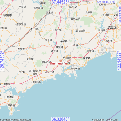
| Upper-left | 37.44525°, | 120.74302° |
| Center: | 36.88494°, | 121.44614° |
| Lower-right: | 36.32048°, | 122.14927° |
| Map W x H: | 125.1×125.1 km | = 77.7×77.7mi |
| max Lat: | 53.31946° ⇑21.1% North |
| Rushanzhai: | 36.88494° |
| min Lat: | ⇓78.9% South 18.22056° |
| min Long | Rushanzhai | max Long |
| 75.07348° | 121.44614° | 134.28917° |
| W 89.8%⇐ | ⇒10.2% E |
Elevation
Elevation of Rushanzhai is 10 m = 33 ft, and this is 474.8 m = 1558 ft below average elevation for this country.
| Max E: |
5622 m = 18445 ft | 89.9% |
| Avg. | 484.8 m = 1591 ft | |
| Rushanzhai | 10 m = 33 ft | |
Min E: |
-3 m = -10 ft | 10.1% |
See also: China elevation on elevation.city.
Geographical zone
Rushanzhai is located in North temperate zone (between Tropic of Cancer and the Arctic Circle). Distance of this Northern Tropic circle is 1495.3 km =929.1 mi to South.| Distance of | km | miles | from Rushanzhai |
|---|---|---|---|
| North Pole | 5905.8 | 3669.7 | to North |
| Arctic Circle | 3300 | 2050.5 | to North |
| Tropic Cancer | 1495.3 | 929.1 | to South |
| Equator | 4101.2 | 2548.4 | to South |


Nearby cities:
15 places around Rushanzhai: (largest is in red/bold)
• Baishatan
22.9 km =14.2 mi,  104°
104°
• Chengqu
7.6 km =4.7 mi,  67°
67°
• Dagushan
16.6 km =10.3 mi,  77°
77°
• Dongcun
28.2 km =17.5 mi,  244°
244°
• Fengjia
26.1 km =16.2 mi,  50°
50°
• Haiyangsuo
17.5 km =10.9 mi,  119°
119°
• Jugezhuang
37.7 km =23.4 mi,  33°
33°
• Nanhuang
32.5 km =20.2 mi, 71°
• Rushankou
5.9 km =3.7 mi,  111°
111°
• Shuidao
33.9 km =21.1 mi,  20°
20°
• Wanggezhuang
31.9 km =19.8 mi,  352°
352°
• Wuji
20.5 km =12.7 mi,  9°
9°
• Xiachu
21.8 km =13.5 mi,  41°
41°
• Xiaoguan
39.1 km =24.3 mi, 74°
• Xujia
27.1 km =16.8 mi, 84°
Sources, notices
• [Note1] Compared only with cities in China existing in our database
• [Src1] Map data: © OpenStreetMap contributors (CC-BY-SA)
• [Src2] Other city data from geonames.org with taken over terms of usage.
• [Src3] Geographical zone / Annual Mean Temperature by Robert A. Rohde @ Wikipedia
