Qujiang geodata
Qujiang (Jiangxi) is a seat of a fourth-order administrative division; located in China in Asia/Shanghai (GMT+8) time zone. In our database, there are 1268 cities with bigger population. Compared to other cities in China, 71.9% of cities are located further ↑North; 58.8% of cities are located further ←West and 72.3% of cities have higher elevation than Qujiang. Note1


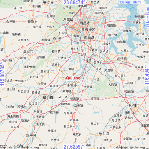
Qujiang GPS coordinates[2]
28° 14' 49.74" North, 115° 47' 27.492" East
| Map corner | latitude | longitude |
|---|---|---|
| Upper-left | 28.86474°, | 115.08785° |
| Center: | 28.24715°, | 115.79097° |
| Lower-right: | 27.62597°, | 116.4941° |
| Map W x H: | 137.7×137.7 km | = 85.6×85.6mi |
| max Lat: | 53.31946° ⇑71.9% North |
| Qujiang: | 28.24715° |
| min Lat: | ⇓28.1% South 18.22056° |
| min Long | Qujiang | max Long |
| 75.07348° | 115.79097° | 134.28917° |
| W 58.8%⇐ | ⇒41.2% E |
Elevation
Elevation of Qujiang is 44 m = 144 ft, and this is 440.8 m = 1446 ft below average elevation for this country.
| Max E: |
5622 m = 18445 ft | 72.3% |
| Avg. | 484.8 m = 1591 ft | |
| Qujiang | 44 m = 144 ft | |
Min E: |
-3 m = -10 ft | 27.7% |
See also: China elevation on elevation.city.
Geographical zone
Qujiang is located in North temperate zone (between Tropic of Cancer and the Arctic Circle). Distance of this Northern Tropic circle is 534.9 km =332.4 mi to South.| Distance of | km | miles | from Qujiang |
|---|---|---|---|
| North Pole | 6866.3 | 4266.5 | to North |
| Arctic Circle | 4260.4 | 2647.3 | to North |
| Tropic Cancer | 534.9 | 332.4 | to South |
| Equator | 3140.8 | 1951.6 | to South |


Nearby cities:
15 places around Qujiang: (largest is in red/bold)
• Baitu
19.4 km =12.1 mi,  103°
103°
• Duantan
16 km =9.9 mi,  81°
81°
• Hutang
19.5 km =12.1 mi,  295°
295°
• Jianguang
6 km =3.7 mi,  186°
186°
• Meilin
13.6 km =8.5 mi,  285°
285°
• Rongtang
17.1 km =10.6 mi,  205°
205°
• Shangtang
7.6 km =4.7 mi,  311°
311°
• Shangzhuang
10.7 km =6.6 mi,  274°
274°
• Shitan
13.8 km =8.6 mi,  160°
160°
• Sundu
12.2 km =7.6 mi, 192°
• Tongtianxiang
9.6 km =6 mi,  11°
11°
• Tuochuan
16.5 km =10.3 mi,  230°
230°
• Xiaogang
7 km =4.3 mi,  90°
90°
• Xiaotang
12.6 km =7.8 mi,  109°
109°
• Zhangxiang
16.1 km =10 mi,  132°
132°
Sources, notices
• [Note1] Compared only with cities in China existing in our database
• [Src1] Map data: © OpenStreetMap contributors (CC-BY-SA)
• [Src2] Other city data from geonames.org with taken over terms of usage.
• [Src3] Geographical zone / Annual Mean Temperature by Robert A. Rohde @ Wikipedia
