Hutang geodata
Hutang (Jiangxi) is a seat of a fourth-order administrative division; located in China in Asia/Shanghai (GMT+8) time zone. In our database, there are 1268 cities with bigger population. Compared to other cities in China, 71.3% of cities are located further ↑North; 57.6% of cities are located further ←West and 78.3% of cities have higher elevation than Hutang. Note1


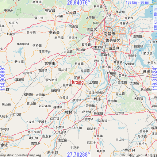
Hutang GPS coordinates[2]
28° 19' 25.032" North, 115° 36' 43.596" East
| Map corner | latitude | longitude |
|---|---|---|
| Upper-left | 28.94076°, | 114.90899° |
| Center: | 28.32362°, | 115.61211° |
| Lower-right: | 27.70288°, | 116.31524° |
| Map W x H: | 137.6×137.6 km | = 85.5×85.5mi |
| max Lat: | 53.31946° ⇑71.3% North |
| Hutang: | 28.32362° |
| min Lat: | ⇓28.7% South 18.22056° |
| min Long | Hutang | max Long |
| 75.07348° | 115.61211° | 134.28917° |
| W 57.6%⇐ | ⇒42.4% E |
Elevation
Elevation of Hutang is 30 m = 98 ft, and this is 454.8 m = 1492 ft below average elevation for this country.
| Max E: |
5622 m = 18445 ft | 78.3% |
| Avg. | 484.8 m = 1591 ft | |
| Hutang | 30 m = 98 ft | |
Min E: |
-3 m = -10 ft | 21.7% |
See also: China elevation on elevation.city.
Geographical zone
Hutang is located in North temperate zone (between Tropic of Cancer and the Arctic Circle). Distance of this Northern Tropic circle is 543.4 km =337.7 mi to South.| Distance of | km | miles | from Hutang |
|---|---|---|---|
| North Pole | 6857.8 | 4261.2 | to North |
| Arctic Circle | 4251.9 | 2642 | to North |
| Tropic Cancer | 543.4 | 337.7 | to South |
| Equator | 3149.3 | 1956.9 | to South |


Nearby cities:
15 places around Hutang: (largest is in red/bold)
• Dongjia
11.4 km =7.1 mi,  241°
241°
• Ducheng
15.5 km =9.6 mi,  229°
229°
• Heling
20 km =12.4 mi,  279°
279°
• Huangcheng
6.4 km =4 mi,  309°
309°
• Lanfangzhen
16.3 km =10.1 mi,  299°
299°
• Liuhu
19.5 km =12.1 mi,  33°
33°
• Meilin
6.6 km =4.1 mi,  138°
138°
• Quangang
18.7 km =11.6 mi,  184°
184°
• Qujiang
19.5 km =12.1 mi,  115°
115°
• Shangtang
12.3 km =7.6 mi,  106°
106°
• Shangzhuang
10.2 km =6.3 mi, 138°
• Shigang
13.3 km =8.3 mi,  5°
5°
• Songhu
7.2 km =4.5 mi, 31°
• Tongtianxiang
19.4 km =12.1 mi,  87°
87°
• Tuochuan
19.5 km =12.1 mi,  165°
165°
Sources, notices
• [Note1] Compared only with cities in China existing in our database
• [Src1] Map data: © OpenStreetMap contributors (CC-BY-SA)
• [Src2] Other city data from geonames.org with taken over terms of usage.
• [Src3] Geographical zone / Annual Mean Temperature by Robert A. Rohde @ Wikipedia
