Tongtianxiang geodata
Tongtianxiang (Jiangxi) is a seat of a fourth-order administrative division; located in China in Asia/Shanghai (GMT+8) time zone. In our database, there are 1268 cities with bigger population. Compared to other cities in China, 71.2% of cities are located further ↑North; 58.9% of cities are located further ←West and 73.3% of cities have higher elevation than Tongtianxiang. Note1


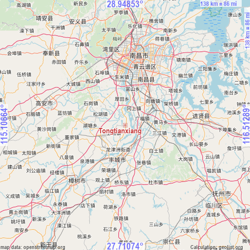
Tongtianxiang GPS coordinates[2]
28° 19' 53.184" North, 115° 48' 35.136" East
| Map corner | latitude | longitude |
|---|---|---|
| Upper-left | 28.94853°, | 115.10664° |
| Center: | 28.33144°, | 115.80976° |
| Lower-right: | 27.71074°, | 116.51289° |
| Map W x H: | 137.6×137.6 km | = 85.5×85.5mi |
| max Lat: | 53.31946° ⇑71.2% North |
| Tongtianxiang: | 28.33144° |
| min Lat: | ⇓28.8% South 18.22056° |
| min Long | Tongtianxiang | max Long |
| 75.07348° | 115.80976° | 134.28917° |
| W 58.9%⇐ | ⇒41.1% E |
Elevation
Elevation of Tongtianxiang is 41 m = 135 ft, and this is 443.8 m = 1456 ft below average elevation for this country.
| Max E: |
5622 m = 18445 ft | 73.3% |
| Avg. | 484.8 m = 1591 ft | |
| Tongtianxiang | 41 m = 135 ft | |
Min E: |
-3 m = -10 ft | 26.7% |
See also: China elevation on elevation.city.
Geographical zone
Tongtianxiang is located in North temperate zone (between Tropic of Cancer and the Arctic Circle). Distance of this Northern Tropic circle is 544.2 km =338.2 mi to South.| Distance of | km | miles | from Tongtianxiang |
|---|---|---|---|
| North Pole | 6856.9 | 4260.7 | to North |
| Arctic Circle | 4251 | 2641.4 | to North |
| Tropic Cancer | 544.2 | 338.2 | to South |
| Equator | 3150.2 | 1957.4 | to South |


Nearby cities:
15 places around Tongtianxiang: (largest is in red/bold)
• Duantan
15.6 km =9.7 mi,  116°
116°
• Gangshang
10.9 km =6.8 mi,  28°
28°
• Houtian
15 km =9.3 mi,  352°
352°
• Hutang
19.4 km =12.1 mi,  267°
267°
• Jianguang
15.5 km =9.6 mi,  189°
189°
• Liuhu
17.6 km =10.9 mi,  330°
330°
• Meilin
16.1 km =10 mi,  248°
248°
• Qujiang
9.6 km =6 mi, 191°
• Sanjiang
19.6 km =12.2 mi,  102°
102°
• Shangtang
8.7 km =5.4 mi,  239°
239°
• Shangzhuang
15.1 km =9.4 mi, 235°
• Songhu
16.5 km =10.3 mi,  288°
288°
• Xiangtang
18.4 km =11.4 mi,  54°
54°
• Xiaogang
10.8 km =6.7 mi,  151°
151°
• Xiaotang
16.9 km =10.5 mi,  143°
143°
Sources, notices
• [Note1] Compared only with cities in China existing in our database
• [Src1] Map data: © OpenStreetMap contributors (CC-BY-SA)
• [Src2] Other city data from geonames.org with taken over terms of usage.
• [Src3] Geographical zone / Annual Mean Temperature by Robert A. Rohde @ Wikipedia
