Qiping geodata
Qiping (Hunan) is a seat of a fourth-order administrative division; located in China in Asia/Shanghai (GMT+8) time zone. In our database, there are 1268 cities with bigger population. Compared to other cities in China, 70.3% of cities are located further ↑North; 70.4% of cities are located further →East and 56.6% of cities have higher elevation than Qiping. Note1


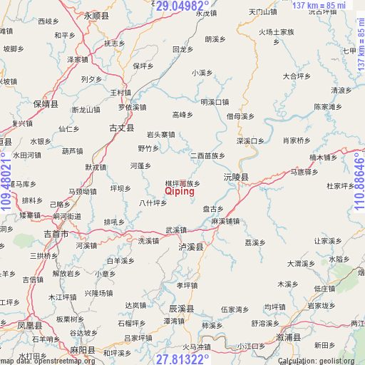
Qiping GPS coordinates[2]
28° 25' 59.988" North, 110° 10' 59.988" East
| Map corner | latitude | longitude |
|---|---|---|
| Upper-left | 29.04982°, | 109.48021° |
| Center: | 28.43333°, | 110.18333° |
| Lower-right: | 27.81322°, | 110.88646° |
| Map W x H: | 137.5×137.5 km | = 85.4×85.4mi |
| max Lat: | 53.31946° ⇑70.3% North |
| Qiping: | 28.43333° |
| min Lat: | ⇓29.7% South 18.22056° |
| min Long | Qiping | max Long |
| 75.07348° | 110.18333° | 134.28917° |
| W 29.6%⇐ | ⇒70.4% E |
Elevation
Elevation of Qiping is 120 m = 394 ft, and this is 364.8 m = 1197 ft below average elevation for this country.
| Max E: |
5622 m = 18445 ft | 56.6% |
| Avg. | 484.8 m = 1591 ft | |
| Qiping | 120 m = 394 ft | |
Min E: |
-3 m = -10 ft | 43.4% |
See also: China elevation on elevation.city.
Geographical zone
Qiping is located in North temperate zone (between Tropic of Cancer and the Arctic Circle). Distance of this Northern Tropic circle is 555.6 km =345.2 mi to South.| Distance of | km | miles | from Qiping |
|---|---|---|---|
| North Pole | 6845.6 | 4253.7 | to North |
| Arctic Circle | 4239.7 | 2634.4 | to North |
| Tropic Cancer | 555.6 | 345.2 | to South |
| Equator | 3161.5 | 1964.5 | to South |


Nearby cities:
15 places around Qiping: (largest is in red/bold)
• Baisha
24 km =14.9 mi,  172°
172°
• Baiyan
22 km =13.7 mi,  248°
248°
• Baiyan
32.5 km =20.2 mi,  267°
267°
• Chuanxi
30.1 km =18.7 mi, 165°
• Gaofeng
25.9 km =16.1 mi,  0°
0°
• Guyang
31.7 km =19.7 mi,  309°
309°
• Mingxikou
32.4 km =20.1 mi,  23°
23°
• Morong
33.4 km =20.8 mi,  280°
280°
• Pingba
23.9 km =14.9 mi,  263°
263°
• Shanzao
9.3 km =5.8 mi,  295°
295°
• Shuangxi
35.8 km =22.2 mi, 304°
• Taiping
35.8 km =22.2 mi, 249°
• Tanxi
29.4 km =18.3 mi,  230°
230°
• Yezhu
18.5 km =11.5 mi,  315°
315°
• Yuanling
21.5 km =13.4 mi,  85°
85°
Sources, notices
• [Note1] Compared only with cities in China existing in our database
• [Src1] Map data: © OpenStreetMap contributors (CC-BY-SA)
• [Src2] Other city data from geonames.org with taken over terms of usage.
• [Src3] Geographical zone / Annual Mean Temperature by Robert A. Rohde @ Wikipedia
