Baisha geodata
Baisha (Hunan) is a seat of a third-order administrative division; located in China in Asia/Shanghai (GMT+8) time zone. In our database, there are 1268 cities with bigger population. Compared to other cities in China, 72.2% of cities are located further ↑North; 70.3% of cities are located further →East and 58.6% of cities have higher elevation than Baisha. Note1


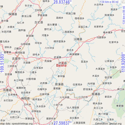
Baisha GPS coordinates[2]
28° 13' 10.956" North, 110° 13' 1.02" East
| Map corner | latitude | longitude |
|---|---|---|
| Upper-left | 28.83746°, | 109.51383° |
| Center: | 28.21971°, | 110.21695° |
| Lower-right: | 27.59837°, | 110.92008° |
| Map W x H: | 137.8×137.8 km | = 85.6×85.6mi |
| max Lat: | 53.31946° ⇑72.2% North |
| Baisha: | 28.21971° |
| min Lat: | ⇓27.8% South 18.22056° |
| min Long | Baisha | max Long |
| 75.07348° | 110.21695° | 134.28917° |
| W 29.7%⇐ | ⇒70.3% E |
Elevation
Elevation of Baisha is 107 m = 351 ft, and this is 377.8 m = 1240 ft below average elevation for this country.
| Max E: |
5622 m = 18445 ft | 58.6% |
| Avg. | 484.8 m = 1591 ft | |
| Baisha | 107 m = 351 ft | |
Min E: |
-3 m = -10 ft | 41.4% |
See also: China elevation on elevation.city.
Geographical zone
Baisha is located in North temperate zone (between Tropic of Cancer and the Arctic Circle). Distance of this Northern Tropic circle is 531.8 km =330.4 mi to South.| Distance of | km | miles | from Baisha |
|---|---|---|---|
| North Pole | 6869.3 | 4268.4 | to North |
| Arctic Circle | 4263.4 | 2649.2 | to North |
| Tropic Cancer | 531.8 | 330.4 | to South |
| Equator | 3137.7 | 1949.7 | to South |


Nearby cities:
15 places around Baisha: (largest is in red/bold)
• Baiyan
28.5 km =17.7 mi,  303°
303°
• Chenyang
23.1 km =14.4 mi,  190°
190°
• Chuanxi
6.9 km =4.3 mi,  141°
141°
• Pingba
34.3 km =21.3 mi,  307°
307°
• Pushi
19.4 km =12.1 mi,  217°
217°
• Qiping
24 km =14.9 mi,  352°
352°
• Shanzao
30.1 km =18.7 mi,  337°
337°
• Tanwan
28.9 km =18 mi, 193°
• Tanxi
26.7 km =16.6 mi,  281°
281°
• Tianwan
14.2 km =8.8 mi,  173°
173°
• Weixi
34.1 km =21.2 mi,  84°
84°
• Xiaozhang
34.1 km =21.2 mi,  252°
252°
• Xiuxi
28 km =17.4 mi,  164°
164°
• Yongping
17.7 km =11 mi,  114°
114°
• Yuanling
31.2 km =19.4 mi,  35°
35°
Sources, notices
• [Note1] Compared only with cities in China existing in our database
• [Src1] Map data: © OpenStreetMap contributors (CC-BY-SA)
• [Src2] Other city data from geonames.org with taken over terms of usage.
• [Src3] Geographical zone / Annual Mean Temperature by Robert A. Rohde @ Wikipedia
