Qinnan geodata
Qinnan (Jiangsu) is a populated place; located in China in Asia/Shanghai (GMT+8) time zone. With population of 55,975 people, there are 782 cities with bigger population in this country. Compared to other cities in China, 67.2% of cities are located further ↓South; 81.3% of cities are located further ←West and 99.7% of cities have higher elevation than Qinnan. Note1


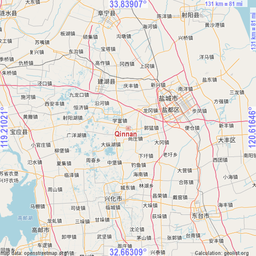
Qinnan GPS coordinates[2]
33° 15' 11.016" North, 119° 54' 47.988" East
| Map corner | latitude | longitude |
|---|---|---|
| Upper-left | 33.83907°, | 119.21021° |
| Center: | 33.25306°, | 119.91333° |
| Lower-right: | 32.66309°, | 120.61646° |
| Map W x H: | 130.8×130.8 km | = 81.3×81.3mi |
| max Lat: | 53.31946° ⇑32.8% North |
| Qinnan: | 33.25306° |
| min Lat: | ⇓67.2% South 18.22056° |
| min Long | Qinnan | max Long |
| 75.07348° | 119.91333° | 134.28917° |
| W 81.3%⇐ | ⇒18.7% E |
Elevation
Elevation of Qinnan is 1 m = 3 ft, and this is 483.8 m = 1587 ft below average elevation for this country.
| Max E: |
5622 m = 18445 ft | 99.7% |
| Avg. | 484.8 m = 1591 ft | |
| Qinnan | 1 m = 3 ft | |
Min E: |
-3 m = -10 ft | 0.3% |
See also: Qinnan elevation on elevation.city.
Geographical zone
Qinnan is located in North temperate zone (between Tropic of Cancer and the Arctic Circle). Distance of this Northern Tropic circle is 1091.5 km =678.2 mi to South.| Distance of | km | miles | from Qinnan |
|---|---|---|---|
| North Pole | 6309.7 | 3920.7 | to North |
| Arctic Circle | 3703.8 | 2301.4 | to North |
| Tropic Cancer | 1091.5 | 678.2 | to South |
| Equator | 3697.4 | 2297.5 | to South |


Nearby cities:
15 places around Qinnan: (largest is in red/bold)
• Anfeng
24.9 km =15.5 mi,  136°
136°
• Changrong
37.7 km =23.4 mi,  155°
155°
• Chengdong
29.9 km =18.6 mi,  180°
180°
• Diaoyumiao
19.4 km =12.1 mi, 163°
• Duotian
36.6 km =22.7 mi,  188°
188°
• Gaojiazhuang
24.1 km =15 mi, 164°
• Guanyinsi
30.9 km =19.2 mi,  126°
126°
• Liuzhuang
37.6 km =23.4 mi,  109°
109°
• Shaoyang
36.7 km =22.8 mi, 191°
• Shaoyang
38 km =23.6 mi, 194°
• Xijiao
36.2 km =22.5 mi,  206°
206°
• Xindu
23.7 km =14.7 mi,  65°
65°
• Xinghua
35.7 km =22.2 mi, 191°
• Yancheng
25.5 km =15.8 mi,  62°
62°
• Yulong
24.8 km =15.4 mi,  54°
54°
Sources, notices
• [Note1] Compared only with cities in China existing in our database
• [Src1] Map data: © OpenStreetMap contributors (CC-BY-SA)
• [Src2] Other city data from geonames.org with taken over terms of usage.
• [Src3] Geographical zone / Annual Mean Temperature by Robert A. Rohde @ Wikipedia
