Xindu geodata
Xindu (Jiangsu) is a seat of a third-order administrative division; located in China in Asia/Shanghai (GMT+8) time zone. In our database, there are 1268 cities with bigger population. Compared to other cities in China, 67.6% of cities are located further ↓South; 82.9% of cities are located further ←West and 99.9% of cities have higher elevation than Xindu. Note1


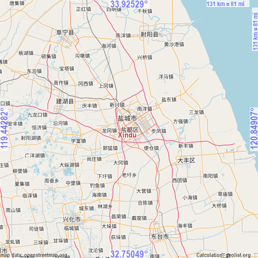
Xindu GPS coordinates[2]
33° 20' 23.532" North, 120° 8' 45.384" East
| Map corner | latitude | longitude |
|---|---|---|
| Upper-left | 33.92529°, | 119.44282° |
| Center: | 33.33987°, | 120.14594° |
| Lower-right: | 32.75049°, | 120.84907° |
| Map W x H: | 130.6×130.6 km | = 81.2×81.2mi |
| max Lat: | 53.31946° ⇑32.4% North |
| Xindu: | 33.33987° |
| min Lat: | ⇓67.6% South 18.22056° |
| min Long | Xindu | max Long |
| 75.07348° | 120.14594° | 134.28917° |
| W 82.9%⇐ | ⇒17.1% E |
Elevation
Elevation of Xindu is 0 m = 0 ft, and this is 484.8 m = 1591 ft below average elevation for this country.
| Max E: |
5622 m = 18445 ft | 99.9% |
| Avg. | 484.8 m = 1591 ft | |
| Xindu | 0 m = 0 ft | |
Min E: |
-3 m = -10 ft | 0.1% |
See also: China elevation on elevation.city.
Geographical zone
Xindu is located in North temperate zone (between Tropic of Cancer and the Arctic Circle). Distance of this Northern Tropic circle is 1101.1 km =684.2 mi to South.| Distance of | km | miles | from Xindu |
|---|---|---|---|
| North Pole | 6300 | 3914.6 | to North |
| Arctic Circle | 3694.1 | 2295.4 | to North |
| Tropic Cancer | 1101.1 | 684.2 | to South |
| Equator | 3707 | 2303.4 | to South |


Nearby cities:
15 places around Xindu: (largest is in red/bold)
• Anfeng
28.2 km =17.5 mi,  189°
189°
• Baiju
33.9 km =21.1 mi,  153°
153°
• Dazhong
32.9 km =20.4 mi,  118°
118°
• Diaoyumiao
32.5 km =20.2 mi,  209°
209°
• Fangqiang
26.4 km =16.4 mi,  80°
80°
• Gaojiazhuang
36.2 km =22.5 mi,  204°
204°
• Guanyinsi
28.2 km =17.5 mi,  173°
173°
• Hechen
38.1 km =23.7 mi, 167°
• Liuzhuang
26.3 km =16.3 mi, 148°
• Qinnan
23.7 km =14.7 mi,  245°
245°
• Sanlong
35 km =21.7 mi, 75°
• Xinfeng
29.7 km =18.5 mi,  105°
105°
• Xituan
36 km =22.4 mi,  135°
135°
• Yancheng
2.2 km =1.4 mi,  28°
28°
• Yulong
5 km =3.1 mi,  343°
343°
Sources, notices
• [Note1] Compared only with cities in China existing in our database
• [Src1] Map data: © OpenStreetMap contributors (CC-BY-SA)
• [Src2] Other city data from geonames.org with taken over terms of usage.
• [Src3] Geographical zone / Annual Mean Temperature by Robert A. Rohde @ Wikipedia
