Qingcheng geodata
Qingcheng (Gansu) is a seat of a fourth-order administrative division; located in China in Asia/Shanghai (GMT+8) time zone. In our database, there are 1268 cities with bigger population. Compared to other cities in China, 77.2% of cities are located further ↓South; 81% of cities are located further →East and 86.7% of cities have lower elevation than Qingcheng. Note1


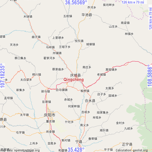
Qingcheng GPS coordinates[2]
35° 59' 56.04" North, 107° 53' 7.692" East
| Map corner | latitude | longitude |
|---|---|---|
| Upper-left | 36.56569°, | 107.18235° |
| Center: | 35.9989°, | 107.88547° |
| Lower-right: | 35.428°, | 108.5886° |
| Map W x H: | 126.5×126.5 km | = 78.6×78.6mi |
| max Lat: | 53.31946° ⇑22.8% North |
| Qingcheng: | 35.9989° |
| min Lat: | ⇓77.2% South 18.22056° |
| min Long | Qingcheng | max Long |
| 75.07348° | 107.88547° | 134.28917° |
| W 19%⇐ | ⇒81% E |
Elevation
Elevation of Qingcheng is 1097 m = 3599 ft, and this is 612.2 m = 2009 ft above average elevation for this country.
| Max E: |
5622 m = 18445 ft | 13.3% |
| Qingcheng | 1097 m 3599 ft | |
| Avg. | 484.8 m = 1591 ft | |
Min E: |
-3 m = -10 ft | 86.7% |
See also: China elevation on elevation.city.
Geographical zone
Qingcheng is located in North temperate zone (between Tropic of Cancer and the Arctic Circle). Distance of this Northern Tropic circle is 1396.8 km =867.9 mi to South.| Distance of | km | miles | from Qingcheng |
|---|---|---|---|
| North Pole | 6004.4 | 3731 | to North |
| Arctic Circle | 3398.5 | 2111.7 | to North |
| Tropic Cancer | 1396.8 | 867.9 | to South |
| Equator | 4002.7 | 2487.2 | to South |


Nearby cities:
15 places around Qingcheng: (largest is in red/bold)
• Binglincha
46.4 km =28.8 mi,  275°
275°
• Caijiamiao
16.2 km =10.1 mi,  292°
292°
• Dijiahe
27.4 km =17 mi,  303°
303°
• Liliangzi
42.9 km =26.7 mi,  351°
351°
• Maling
32.6 km =20.3 mi,  318°
318°
• Nanjie
37 km =23 mi,  217°
217°
• Nanzhuang
11.6 km =7.2 mi,  48°
48°
• Sanshilipu
14.6 km =9.1 mi, 318°
• Shangliyuan
35.5 km =22.1 mi,  334°
334°
• Tongchuan
33.1 km =20.6 mi,  273°
273°
• Wangzuizi
26.8 km =16.7 mi,  338°
338°
• Wentai
40.7 km =25.3 mi,  2°
2°
• Xihuachi
23.3 km =14.5 mi,  150°
150°
• Xuanma
8.7 km =5.4 mi, 3°
• Yuele
29.7 km =18.5 mi, 4°
Sources, notices
• [Note1] Compared only with cities in China existing in our database
• [Src1] Map data: © OpenStreetMap contributors (CC-BY-SA)
• [Src2] Other city data from geonames.org with taken over terms of usage.
• [Src3] Geographical zone / Annual Mean Temperature by Robert A. Rohde @ Wikipedia
