Sanshilipu geodata
Sanshilipu (Gansu) is a seat of a fourth-order administrative division; located in China in Asia/Shanghai (GMT+8) time zone. In our database, there are 1268 cities with bigger population. Compared to other cities in China, 77.4% of cities are located further ↓South; 81.3% of cities are located further →East and 86.8% of cities have lower elevation than Sanshilipu. Note1


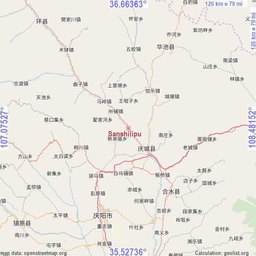
Sanshilipu GPS coordinates[2]
36° 5' 51.18" North, 107° 46' 42.204" East
| Map corner | latitude | longitude |
|---|---|---|
| Upper-left | 36.66363°, | 107.07527° |
| Center: | 36.09755°, | 107.77839° |
| Lower-right: | 35.52736°, | 108.48152° |
| Map W x H: | 126.3×126.3 km | = 78.5×78.5mi |
| max Lat: | 53.31946° ⇑22.6% North |
| Sanshilipu: | 36.09755° |
| min Lat: | ⇓77.4% South 18.22056° |
| min Long | Sanshilipu | max Long |
| 75.07348° | 107.77839° | 134.28917° |
| W 18.7%⇐ | ⇒81.3% E |
Elevation
Elevation of Sanshilipu is 1101 m = 3612 ft, and this is 616.2 m = 2022 ft above average elevation for this country.
| Max E: |
5622 m = 18445 ft | 13.2% |
| Sanshilipu | 1101 m 3612 ft | |
| Avg. | 484.8 m = 1591 ft | |
Min E: |
-3 m = -10 ft | 86.8% |
See also: China elevation on elevation.city.
Geographical zone
Sanshilipu is located in North temperate zone (between Tropic of Cancer and the Arctic Circle). Distance of this Northern Tropic circle is 1407.8 km =874.8 mi to South.| Distance of | km | miles | from Sanshilipu |
|---|---|---|---|
| North Pole | 5993.4 | 3724.1 | to North |
| Arctic Circle | 3387.5 | 2104.9 | to North |
| Tropic Cancer | 1407.8 | 874.8 | to South |
| Equator | 4013.7 | 2494 | to South |


Nearby cities:
15 places around Sanshilipu: (largest is in red/bold)
• Caijiamiao
7.2 km =4.5 mi,  228°
228°
• Caikouji
36.9 km =22.9 mi,  276°
276°
• Dijiahe
13.8 km =8.6 mi,  288°
288°
• Liliangzi
31.7 km =19.7 mi,  6°
6°
• Maling
18 km =11.2 mi,  317°
317°
• Nanzhuang
18.6 km =11.6 mi,  100°
100°
• Qingcheng
14.6 km =9.1 mi,  138°
138°
• Quzi
32.3 km =20.1 mi,  312°
312°
• Shangliyuan
21.8 km =13.5 mi,  345°
345°
• Tongchuan
25.1 km =15.6 mi,  248°
248°
• Wangzuizi
14 km =8.7 mi,  359°
359°
• Wentai
31.9 km =19.8 mi,  21°
21°
• Xuanma
10.4 km =6.5 mi, 102°
• Xujiahe
32 km =19.9 mi,  328°
328°
• Yuele
22.1 km =13.7 mi,  32°
32°
Sources, notices
• [Note1] Compared only with cities in China existing in our database
• [Src1] Map data: © OpenStreetMap contributors (CC-BY-SA)
• [Src2] Other city data from geonames.org with taken over terms of usage.
• [Src3] Geographical zone / Annual Mean Temperature by Robert A. Rohde @ Wikipedia
