Binglincha geodata
Binglincha (Gansu) is a seat of a fourth-order administrative division; located in China in Asia/Shanghai (GMT+8) time zone. In our database, there are 1268 cities with bigger population. Compared to other cities in China, 77.3% of cities are located further ↓South; 82.6% of cities are located further →East and 90.4% of cities have lower elevation than Binglincha. Note1


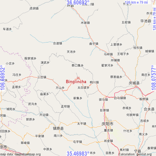
Binglincha GPS coordinates[2]
36° 2' 25.548" North, 107° 22' 21.504" East
| Map corner | latitude | longitude |
|---|---|---|
| Upper-left | 36.60692°, | 106.66952° |
| Center: | 36.04043°, | 107.37264° |
| Lower-right: | 35.46983°, | 108.07577° |
| Map W x H: | 126.4×126.4 km | = 78.5×78.5mi |
| max Lat: | 53.31946° ⇑22.7% North |
| Binglincha: | 36.04043° |
| min Lat: | ⇓77.3% South 18.22056° |
| min Long | Binglincha | max Long |
| 75.07348° | 107.37264° | 134.28917° |
| W 17.4%⇐ | ⇒82.6% E |
Elevation
Elevation of Binglincha is 1390 m = 4560 ft, and this is 905.2 m = 2970 ft above average elevation for this country.
| Max E: |
5622 m = 18445 ft | 9.6% |
| Binglincha | 1390 m 4560 ft | |
| Avg. | 484.8 m = 1591 ft | |
Min E: |
-3 m = -10 ft | 90.4% |
See also: China elevation on elevation.city.
Geographical zone
Binglincha is located in North temperate zone (between Tropic of Cancer and the Arctic Circle). Distance of this Northern Tropic circle is 1401.4 km =870.8 mi to South.| Distance of | km | miles | from Binglincha |
|---|---|---|---|
| North Pole | 5999.7 | 3728 | to North |
| Arctic Circle | 3393.9 | 2108.9 | to North |
| Tropic Cancer | 1401.4 | 870.8 | to South |
| Equator | 4007.3 | 2490 | to South |


Nearby cities:
15 places around Binglincha: (largest is in red/bold)
• Caijiamiao
31.1 km =19.3 mi,  87°
87°
• Caikouji
10.5 km =6.5 mi,  358°
358°
• Dijiahe
25.7 km =16 mi,  65°
65°
• Hedao
33 km =20.5 mi,  329°
329°
• Heping
40 km =24.9 mi,  324°
324°
• Maling
31.3 km =19.4 mi,  50°
50°
• Nanjie
41.3 km =25.7 mi,  145°
145°
• Quzi
30.8 km =19.1 mi,  23°
23°
• Sancha
29.4 km =18.3 mi,  272°
272°
• Sanshilipu
37 km =23 mi,  80°
80°
• Tianchi
22.5 km =14 mi,  345°
345°
• Tongchuan
13.4 km =8.3 mi,  101°
101°
• Wuchengzi
11.7 km =7.3 mi,  303°
303°
• Xujiahe
39.1 km =24.3 mi,  30°
30°
• Yanwu
29.9 km =18.6 mi, 295°
Sources, notices
• [Note1] Compared only with cities in China existing in our database
• [Src1] Map data: © OpenStreetMap contributors (CC-BY-SA)
• [Src2] Other city data from geonames.org with taken over terms of usage.
• [Src3] Geographical zone / Annual Mean Temperature by Robert A. Rohde @ Wikipedia
