Qingtuozi geodata
Qingtuozi (Tianjin) is a populated place; located in China in Asia/Shanghai (GMT+8) time zone. With population of 538 people, there are 1261 cities with bigger population in this country. Compared to other cities in China, 83.3% of cities are located further ↓South; 69.6% of cities are located further ←West and 99.9% of cities have higher elevation than Qingtuozi. Note1


Qingtuozi GPS coordinates[2]
39° 7' 23.988" North, 117° 44' 51" East
| Map corner | latitude | longitude |
|---|---|---|
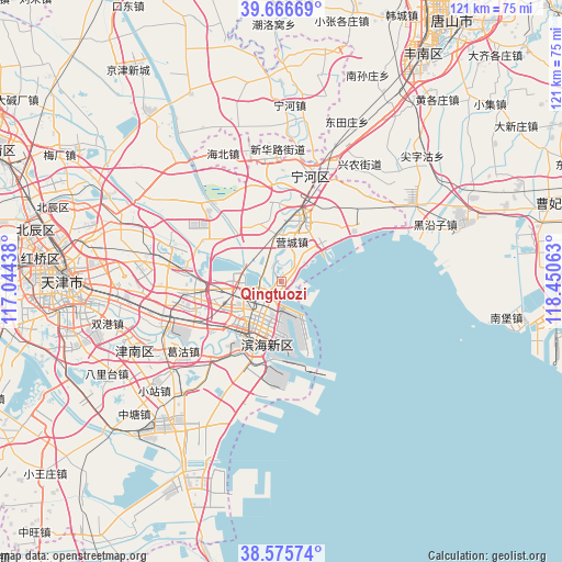
| Upper-left | 39.66669°, | 117.04438° |
| Center: | 39.12333°, | 117.7475° |
| Lower-right: | 38.57574°, | 118.45063° |
| Map W x H: | 121.3×121.3 km | = 75.4×75.4mi |
| max Lat: | 53.31946° ⇑16.7% North |
| Qingtuozi: | 39.12333° |
| min Lat: | ⇓83.3% South 18.22056° |
| min Long | Qingtuozi | max Long |
| 75.07348° | 117.7475° | 134.28917° |
| W 69.6%⇐ | ⇒30.4% E |
Elevation
Elevation of Qingtuozi is 0 m = 0 ft, and this is 484.8 m = 1591 ft below average elevation for this country.
| Max E: |
5622 m = 18445 ft | 99.9% |
| Avg. | 484.8 m = 1591 ft | |
| Qingtuozi | 0 m = 0 ft | |
Min E: |
-3 m = -10 ft | 0.1% |
See also: China elevation on elevation.city.
Geographical zone
Qingtuozi is located in North temperate zone (between Tropic of Cancer and the Arctic Circle). Distance of this Northern Tropic circle is 1744.2 km =1083.8 mi to South.| Distance of | km | miles | from Qingtuozi |
|---|---|---|---|
| North Pole | 5657 | 3515.1 | to North |
| Arctic Circle | 3051.1 | 1895.9 | to North |
| Tropic Cancer | 1744.2 | 1083.8 | to South |
| Equator | 4350.1 | 2703 | to South |


Nearby cities:
15 places around Qingtuozi: (largest is in red/bold)
• Beihuaidian
21.8 km =13.5 mi,  313°
313°
• Caijiapu
7.8 km =4.8 mi,  44°
44°
• Chadian
11.3 km =7 mi,  0°
0°
• Chengtougu
3.3 km =2.1 mi,  55°
55°
• Dashentang
20.5 km =12.7 mi, 59°
• Datianzhuang
16.6 km =10.3 mi, 1°
• Duli
22.1 km =13.7 mi,  346°
346°
• Hangu
14.4 km =8.9 mi,  14°
14°
• Ningchegu
8.3 km =5.2 mi,  298°
298°
• Qiaogu
21.1 km =13.1 mi, 354°
• Renfengzhuang
22.2 km =13.8 mi,  340°
340°
• Tanggu
14.3 km =8.9 mi,  217°
217°
• Xinhe
14.3 km =8.9 mi,  229°
229°
• Yangjiapo
22.5 km =14 mi,  32°
32°
• Zhongxinqiao
18.7 km =11.6 mi,  239°
239°
Sources, notices
• [Note1] Compared only with cities in China existing in our database
• [Src1] Map data: © OpenStreetMap contributors (CC-BY-SA)
• [Src2] Other city data from geonames.org with taken over terms of usage.
• [Src3] Geographical zone / Annual Mean Temperature by Robert A. Rohde @ Wikipedia
