Datianzhuang geodata
Datianzhuang (Tianjin) is a populated place; located in China in Asia/Shanghai (GMT+8) time zone. With population of 2,254 people, there are 1006 cities with bigger population in this country. Compared to other cities in China, 84% of cities are located further ↓South; 69.7% of cities are located further ←West and 99.7% of cities have higher elevation than Datianzhuang. Note1


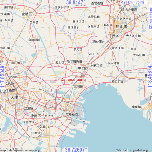
Datianzhuang GPS coordinates[2]
39° 16' 21" North, 117° 45' 12.996" East
| Map corner | latitude | longitude |
|---|---|---|
| Upper-left | 39.8147°, | 117.05049° |
| Center: | 39.2725°, | 117.75361° |
| Lower-right: | 38.72607°, | 118.45674° |
| Map W x H: | 121×121 km | = 75.2×75.2mi |
| max Lat: | 53.31946° ⇑16% North |
| Datianzhuang: | 39.2725° |
| min Lat: | ⇓84% South 18.22056° |
| min Long | Datianzhuang | max Long |
| 75.07348° | 117.75361° | 134.28917° |
| W 69.7%⇐ | ⇒30.3% E |
Elevation
Elevation of Datianzhuang is 1 m = 3 ft, and this is 483.8 m = 1587 ft below average elevation for this country.
| Max E: |
5622 m = 18445 ft | 99.7% |
| Avg. | 484.8 m = 1591 ft | |
| Datianzhuang | 1 m = 3 ft | |
Min E: |
-3 m = -10 ft | 0.3% |
See also: China elevation on elevation.city.
Geographical zone
Datianzhuang is located in North temperate zone (between Tropic of Cancer and the Arctic Circle). Distance of this Northern Tropic circle is 1760.8 km =1094.1 mi to South.| Distance of | km | miles | from Datianzhuang |
|---|---|---|---|
| North Pole | 5640.4 | 3504.8 | to North |
| Arctic Circle | 3034.5 | 1885.6 | to North |
| Tropic Cancer | 1760.8 | 1094.1 | to South |
| Equator | 4366.7 | 2713.3 | to South |


Nearby cities:
15 places around Datianzhuang: (largest is in red/bold)
• Beihuaidian
16.4 km =10.2 mi,  264°
264°
• Caijiapu
12.1 km =7.5 mi,  156°
156°
• Chadian
5.3 km =3.3 mi,  184°
184°
• Chengtougu
14.9 km =9.3 mi,  171°
171°
• Dashentang
18.2 km =11.3 mi,  109°
109°
• Duli
7.4 km =4.6 mi,  311°
311°
• Fuzhuang
15.6 km =9.7 mi,  92°
92°
• Hangu
4 km =2.5 mi,  130°
130°
• Lianzhuang
15.3 km =9.5 mi,  0°
0°
• Miaozhuang
17.2 km =10.7 mi,  14°
14°
• Ningchegu
14.9 km =9.3 mi,  211°
211°
• Qiaogu
5.1 km =3.2 mi,  330°
330°
• Qingtuozi
16.6 km =10.3 mi, 181°
• Renfengzhuang
9 km =5.6 mi,  298°
298°
• Yangjiapo
11.8 km =7.3 mi,  78°
78°
Sources, notices
• [Note1] Compared only with cities in China existing in our database
• [Src1] Map data: © OpenStreetMap contributors (CC-BY-SA)
• [Src2] Other city data from geonames.org with taken over terms of usage.
• [Src3] Geographical zone / Annual Mean Temperature by Robert A. Rohde @ Wikipedia
