Chadian geodata
Chadian (Tianjin) is a populated place; located in China in Asia/Shanghai (GMT+8) time zone. With population of 3,355 people, there are 930 cities with bigger population in this country. Compared to other cities in China, 83.8% of cities are located further ↓South; 69.7% of cities are located further ←West and 99.7% of cities have higher elevation than Chadian. Note1


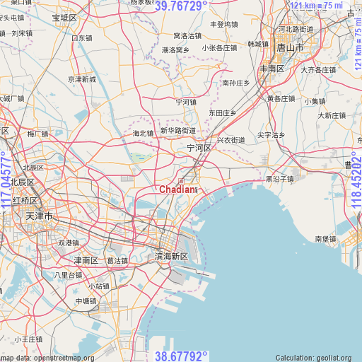
Chadian GPS coordinates[2]
39° 13' 28.992" North, 117° 44' 56.004" East
| Map corner | latitude | longitude |
|---|---|---|
| Upper-left | 39.76729°, | 117.04577° |
| Center: | 39.22472°, | 117.74889° |
| Lower-right: | 38.67792°, | 118.45202° |
| Map W x H: | 121.1×121.1 km | = 75.2×75.2mi |
| max Lat: | 53.31946° ⇑16.2% North |
| Chadian: | 39.22472° |
| min Lat: | ⇓83.8% South 18.22056° |
| min Long | Chadian | max Long |
| 75.07348° | 117.74889° | 134.28917° |
| W 69.7%⇐ | ⇒30.3% E |
Elevation
Elevation of Chadian is 1 m = 3 ft, and this is 483.8 m = 1587 ft below average elevation for this country.
| Max E: |
5622 m = 18445 ft | 99.7% |
| Avg. | 484.8 m = 1591 ft | |
| Chadian | 1 m = 3 ft | |
Min E: |
-3 m = -10 ft | 0.3% |
See also: China elevation on elevation.city.
Geographical zone
Chadian is located in North temperate zone (between Tropic of Cancer and the Arctic Circle). Distance of this Northern Tropic circle is 1755.5 km =1090.8 mi to South.| Distance of | km | miles | from Chadian |
|---|---|---|---|
| North Pole | 5645.7 | 3508.1 | to North |
| Arctic Circle | 3039.8 | 1888.8 | to North |
| Tropic Cancer | 1755.5 | 1090.8 | to South |
| Equator | 4361.4 | 2710 | to South |


Nearby cities:
15 places around Chadian: (largest is in red/bold)
• Beihuaidian
16.4 km =10.2 mi,  283°
283°
• Biaokou
20.2 km =12.6 mi,  303°
303°
• Caijiapu
7.8 km =4.8 mi,  137°
137°
• Chengtougu
9.8 km =6.1 mi,  164°
164°
• Dashentang
17.6 km =10.9 mi,  92°
92°
• Datianzhuang
5.3 km =3.3 mi,  4°
4°
• Duli
11.5 km =7.1 mi,  333°
333°
• Fuzhuang
16.6 km =10.3 mi,  73°
73°
• Gaozhuang
20.1 km =12.5 mi,  75°
75°
• Hangu
4.4 km =2.7 mi,  52°
52°
• Ningchegu
10.4 km =6.5 mi,  225°
225°
• Qiaogu
10 km =6.2 mi,  347°
347°
• Qingtuozi
11.3 km =7 mi,  180°
180°
• Renfengzhuang
12.2 km =7.6 mi,  322°
322°
• Yangjiapo
14.2 km =8.8 mi,  57°
57°
Sources, notices
• [Note1] Compared only with cities in China existing in our database
• [Src1] Map data: © OpenStreetMap contributors (CC-BY-SA)
• [Src2] Other city data from geonames.org with taken over terms of usage.
• [Src3] Geographical zone / Annual Mean Temperature by Robert A. Rohde @ Wikipedia
