Qingkou geodata
Qingkou (Jiangsu) is a seat of a third-order administrative division; located in China in Asia/Shanghai (GMT+8) time zone. In our database, there are 1268 cities with bigger population. Compared to other cities in China, 74.5% of cities are located further ↓South; 76.6% of cities are located further ←West and 98.9% of cities have higher elevation than Qingkou. Note1


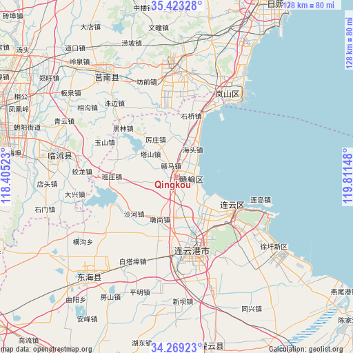
Qingkou GPS coordinates[2]
34° 50' 53.808" North, 119° 6' 30.06" East
| Map corner | latitude | longitude |
|---|---|---|
| Upper-left | 35.42328°, | 118.40523° |
| Center: | 34.84828°, | 119.10835° |
| Lower-right: | 34.26923°, | 119.81148° |
| Map W x H: | 128.3×128.3 km | = 79.7×79.7mi |
| max Lat: | 53.31946° ⇑25.5% North |
| Qingkou: | 34.84828° |
| min Lat: | ⇓74.5% South 18.22056° |
| min Long | Qingkou | max Long |
| 75.07348° | 119.10835° | 134.28917° |
| W 76.6%⇐ | ⇒23.4% E |
Elevation
Elevation of Qingkou is 3 m = 10 ft, and this is 481.8 m = 1581 ft below average elevation for this country.
| Max E: |
5622 m = 18445 ft | 98.9% |
| Avg. | 484.8 m = 1591 ft | |
| Qingkou | 3 m = 10 ft | |
Min E: |
-3 m = -10 ft | 1.1% |
See also: China elevation on elevation.city.
Geographical zone
Qingkou is located in North temperate zone (between Tropic of Cancer and the Arctic Circle). Distance of this Northern Tropic circle is 1268.8 km =788.4 mi to South.| Distance of | km | miles | from Qingkou |
|---|---|---|---|
| North Pole | 6132.3 | 3810.4 | to North |
| Arctic Circle | 3526.4 | 2191.2 | to North |
| Tropic Cancer | 1268.8 | 788.4 | to South |
| Equator | 3874.8 | 2407.7 | to South |


Nearby cities:
15 places around Qingkou: (largest is in red/bold)
• Andongwei
34.8 km =21.6 mi,  26°
26°
• Chaoyang
25.3 km =15.7 mi,  136°
136°
• Dunshang
16.8 km =10.4 mi,  202°
202°
• Haitou
11 km =6.8 mi, 30°
• Haizhou
29.7 km =18.5 mi,  176°
176°
• Huaguoshan
25.7 km =16 mi,  153°
153°
• Jinping
36.9 km =22.9 mi, 178°
• Lianyun
33.1 km =20.6 mi,  112°
112°
• Lianyungang
29.5 km =18.3 mi,  160°
160°
• Luoyang
15.3 km =9.5 mi, 180°
• Nancheng
33.6 km =20.9 mi, 161°
• Songzhuang
7.8 km =4.8 mi, 158°
• Xinpu
28 km =17.4 mi,  170°
170°
• Yunshan
28.8 km =17.9 mi,  124°
124°
• Zhongyun
35.2 km =21.9 mi,  128°
128°
Sources, notices
• [Note1] Compared only with cities in China existing in our database
• [Src1] Map data: © OpenStreetMap contributors (CC-BY-SA)
• [Src2] Other city data from geonames.org with taken over terms of usage.
• [Src3] Geographical zone / Annual Mean Temperature by Robert A. Rohde @ Wikipedia
