Chaoyang geodata
Chaoyang (Jiangsu) is a seat of a fourth-order administrative division; located in China in Asia/Shanghai (GMT+8) time zone. In our database, there are 1268 cities with bigger population. Compared to other cities in China, 73.6% of cities are located further ↓South; 77.6% of cities are located further ←West and 86.2% of cities have higher elevation than Chaoyang. Note1


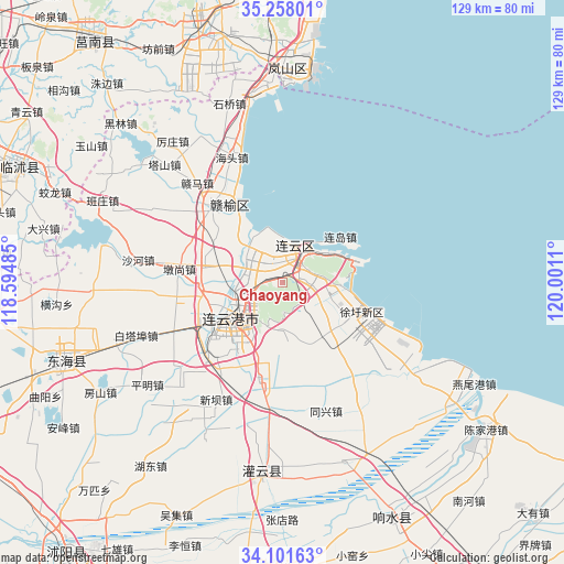
Chaoyang GPS coordinates[2]
34° 40' 54.624" North, 119° 17' 52.692" East
| Map corner | latitude | longitude |
|---|---|---|
| Upper-left | 35.25801°, | 118.59485° |
| Center: | 34.68184°, | 119.29797° |
| Lower-right: | 34.10163°, | 120.0011° |
| Map W x H: | 128.6×128.6 km | = 79.9×79.9mi |
| max Lat: | 53.31946° ⇑26.4% North |
| Chaoyang: | 34.68184° |
| min Lat: | ⇓73.6% South 18.22056° |
| min Long | Chaoyang | max Long |
| 75.07348° | 119.29797° | 134.28917° |
| W 77.6%⇐ | ⇒22.4% E |
Elevation
Elevation of Chaoyang is 14 m = 46 ft, and this is 470.8 m = 1545 ft below average elevation for this country.
| Max E: |
5622 m = 18445 ft | 86.2% |
| Avg. | 484.8 m = 1591 ft | |
| Chaoyang | 14 m = 46 ft | |
Min E: |
-3 m = -10 ft | 13.8% |
See also: China elevation on elevation.city.
Geographical zone
Chaoyang is located in North temperate zone (between Tropic of Cancer and the Arctic Circle). Distance of this Northern Tropic circle is 1250.3 km =776.9 mi to South.| Distance of | km | miles | from Chaoyang |
|---|---|---|---|
| North Pole | 6150.8 | 3821.9 | to North |
| Arctic Circle | 3544.9 | 2202.7 | to North |
| Tropic Cancer | 1250.3 | 776.9 | to South |
| Equator | 3856.3 | 2396.2 | to South |


Nearby cities:
15 places around Chaoyang: (largest is in red/bold)
• Banpu
23.4 km =14.5 mi,  191°
191°
• Dunshang
23.9 km =14.9 mi,  277°
277°
• Gaogongdao
16.3 km =10.1 mi,  84°
84°
• Haizhou
19.1 km =11.9 mi,  234°
234°
• Huaguoshan
7.4 km =4.6 mi, 232°
• Jinping
24.8 km =15.4 mi,  222°
222°
• Lianyun
14.3 km =8.9 mi,  67°
67°
• Lianyungang
12 km =7.5 mi, 219°
• Luoyang
17.8 km =11.1 mi, 280°
• Nancheng
15 km =9.3 mi,  206°
206°
• Qingkou
25.3 km =15.7 mi,  316°
316°
• Songzhuang
18.3 km =11.4 mi,  308°
308°
• Xinpu
15.6 km =9.7 mi, 234°
• Yunshan
6.6 km =4.1 mi, 72°
• Zhongyun
10.7 km =6.6 mi,  109°
109°
Sources, notices
• [Note1] Compared only with cities in China existing in our database
• [Src1] Map data: © OpenStreetMap contributors (CC-BY-SA)
• [Src2] Other city data from geonames.org with taken over terms of usage.
• [Src3] Geographical zone / Annual Mean Temperature by Robert A. Rohde @ Wikipedia
