Xiumei geodata
Xiumei (Hunan) is a seat of a fourth-order administrative division; located in China in Asia/Shanghai (GMT+8) time zone. In our database, there are 1268 cities with bigger population. Compared to other cities in China, 59.6% of cities are located further ↑North; 64.4% of cities are located further →East and 66.4% of cities have higher elevation than Xiumei. Note1


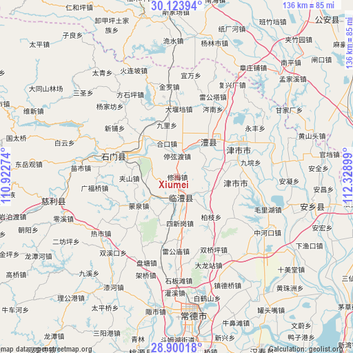
Xiumei GPS coordinates[2]
29° 30' 50.076" North, 111° 37' 33.096" East
| Map corner | latitude | longitude |
|---|---|---|
| Upper-left | 30.12394°, | 110.92274° |
| Center: | 29.51391°, | 111.62586° |
| Lower-right: | 28.90018°, | 112.32899° |
| Map W x H: | 136.1×136.1 km | = 84.6×84.6mi |
| max Lat: | 53.31946° ⇑59.6% North |
| Xiumei: | 29.51391° |
| min Lat: | ⇓40.4% South 18.22056° |
| min Long | Xiumei | max Long |
| 75.07348° | 111.62586° | 134.28917° |
| W 35.6%⇐ | ⇒64.4% E |
Elevation
Elevation of Xiumei is 67 m = 220 ft, and this is 417.8 m = 1371 ft below average elevation for this country.
| Max E: |
5622 m = 18445 ft | 66.4% |
| Avg. | 484.8 m = 1591 ft | |
| Xiumei | 67 m = 220 ft | |
Min E: |
-3 m = -10 ft | 33.6% |
See also: China elevation on elevation.city.
Geographical zone
Xiumei is located in North temperate zone (between Tropic of Cancer and the Arctic Circle). Distance of this Northern Tropic circle is 675.7 km =419.9 mi to South.| Distance of | km | miles | from Xiumei |
|---|---|---|---|
| North Pole | 6725.4 | 4179 | to North |
| Arctic Circle | 4119.5 | 2559.7 | to North |
| Tropic Cancer | 675.7 | 419.9 | to South |
| Equator | 3281.6 | 2039.1 | to South |


Nearby cities:
15 places around Xiumei: (largest is in red/bold)
• Daohe
10.5 km =6.5 mi,  70°
70°
• Daping
16.5 km =10.3 mi,  5°
5°
• Fenghuo
13.3 km =8.3 mi,  117°
117°
• Hekou
13.5 km =8.4 mi,  340°
340°
• Jiashan
18.1 km =11.2 mi,  268°
268°
• Linli
7.5 km =4.7 mi,  161°
161°
• Li’nan
17.1 km =10.6 mi,  47°
47°
• Shanban
10.8 km =6.7 mi,  296°
296°
• Sheshiqiao
13.1 km =8.1 mi,  232°
232°
• Sixingang
17.2 km =10.7 mi,  176°
176°
• Tingxiandu
8.2 km =5.1 mi,  359°
359°
• Wangcheng
11.2 km =7 mi,  167°
167°
• Wenjia
16.8 km =10.4 mi,  207°
207°
• Yangban
6.5 km =4 mi, 74°
• Zhanggongmiao
10 km =6.2 mi, 11°
Sources, notices
• [Note1] Compared only with cities in China existing in our database
• [Src1] Map data: © OpenStreetMap contributors (CC-BY-SA)
• [Src2] Other city data from geonames.org with taken over terms of usage.
• [Src3] Geographical zone / Annual Mean Temperature by Robert A. Rohde @ Wikipedia
