Wangcheng geodata
Wangcheng (Hunan) is a seat of a fourth-order administrative division; located in China in Asia/Shanghai (GMT+8) time zone. In our database, there are 1268 cities with bigger population. Compared to other cities in China, 60.6% of cities are located further ↑North; 64.3% of cities are located further →East and 63.9% of cities have higher elevation than Wangcheng. Note1


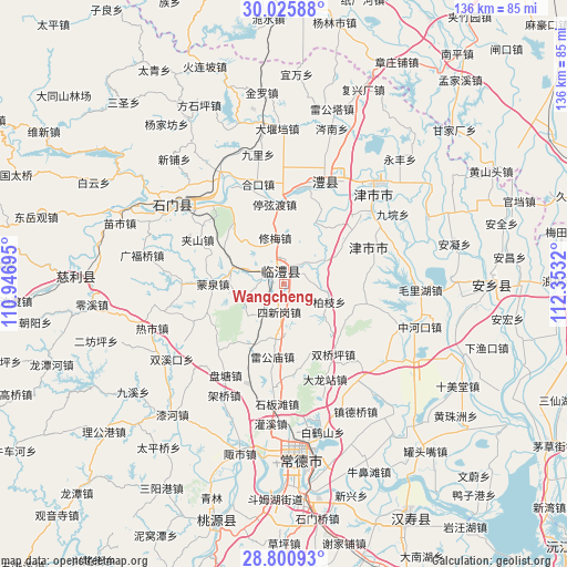
Wangcheng GPS coordinates[2]
29° 24' 54.9" North, 111° 39' 0.252" East
| Map corner | latitude | longitude |
|---|---|---|
| Upper-left | 30.02588°, | 110.94695° |
| Center: | 29.41525°, | 111.65007° |
| Lower-right: | 28.80093°, | 112.3532° |
| Map W x H: | 136.2×136.2 km | = 84.6×84.6mi |
| max Lat: | 53.31946° ⇑60.6% North |
| Wangcheng: | 29.41525° |
| min Lat: | ⇓39.4% South 18.22056° |
| min Long | Wangcheng | max Long |
| 75.07348° | 111.65007° | 134.28917° |
| W 35.7%⇐ | ⇒64.3% E |
Elevation
Elevation of Wangcheng is 78 m = 256 ft, and this is 406.8 m = 1335 ft below average elevation for this country.
| Max E: |
5622 m = 18445 ft | 63.9% |
| Avg. | 484.8 m = 1591 ft | |
| Wangcheng | 78 m = 256 ft | |
Min E: |
-3 m = -10 ft | 36.1% |
See also: China elevation on elevation.city.
Geographical zone
Wangcheng is located in North temperate zone (between Tropic of Cancer and the Arctic Circle). Distance of this Northern Tropic circle is 664.8 km =413.1 mi to South.| Distance of | km | miles | from Wangcheng |
|---|---|---|---|
| North Pole | 6736.4 | 4185.8 | to North |
| Arctic Circle | 4130.5 | 2566.6 | to North |
| Tropic Cancer | 664.8 | 413.1 | to South |
| Equator | 3270.7 | 2032.3 | to South |


Nearby cities:
15 places around Wangcheng: (largest is in red/bold)
• Baizhi
11.5 km =7.1 mi,  112°
112°
• Chen’er
8.5 km =5.3 mi,  200°
200°
• Daohe
16.3 km =10.1 mi,  27°
27°
• Fenghuo
10.6 km =6.6 mi,  62°
62°
• Leigongmiao
17.9 km =11.1 mi,  190°
190°
• Linli
3.9 km =2.4 mi,  359°
359°
• Mengquan
17 km =10.6 mi,  269°
269°
• Shanban
19.8 km =12.3 mi,  322°
322°
• Sheshiqiao
13.1 km =8.1 mi,  283°
283°
• Sixingang
6.3 km =3.9 mi, 192°
• Taifu
15.4 km =9.6 mi, 204°
• Tingxiandu
19.3 km =12 mi,  352°
352°
• Wenjia
10.9 km =6.8 mi,  249°
249°
• Xiumei
11.2 km =7 mi, 347°
• Yangban
13.3 km =8.3 mi,  17°
17°
Sources, notices
• [Note1] Compared only with cities in China existing in our database
• [Src1] Map data: © OpenStreetMap contributors (CC-BY-SA)
• [Src2] Other city data from geonames.org with taken over terms of usage.
• [Src3] Geographical zone / Annual Mean Temperature by Robert A. Rohde @ Wikipedia
