Pingxiang geodata
Pingxiang (Jiangxi) is a seat of a second-order administrative division; located in China in Asia/Shanghai (GMT+8) time zone. With population of 372,123 people, there are 159 cities with bigger population in this country. Compared to other cities in China, 76.2% of cities are located further ↑North; 52.2% of cities are located further →East and 50.2% of cities have lower elevation than Pingxiang. Note1


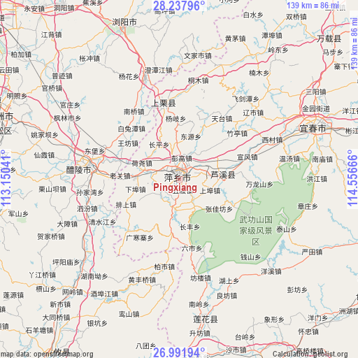
Pingxiang GPS coordinates[2]
27° 37' 0.192" North, 113° 51' 12.708" East
| Map corner | latitude | longitude |
|---|---|---|
| Upper-left | 28.23796°, | 113.15041° |
| Center: | 27.61672°, | 113.85353° |
| Lower-right: | 26.99194°, | 114.55666° |
| Map W x H: | 138.5×138.5 km | = 86.1×86.1mi |
| max Lat: | 53.31946° ⇑76.2% North |
| Pingxiang: | 27.61672° |
| min Lat: | ⇓23.8% South 18.22056° |
| min Long | Pingxiang | max Long |
| 75.07348° | 113.85353° | 134.28917° |
| W 47.8%⇐ | ⇒52.2% E |
Elevation
Elevation of Pingxiang is 167 m = 548 ft, and this is 317.8 m = 1043 ft below average elevation for this country.
| Max E: |
5622 m = 18445 ft | 49.8% |
| Avg. | 484.8 m = 1591 ft | |
| Pingxiang | 167 m = 548 ft | |
Min E: |
-3 m = -10 ft | 50.2% |
See also: Pingxiang elevation on elevation.city.
Geographical zone
Pingxiang is located in North temperate zone (between Tropic of Cancer and the Arctic Circle). Distance of this Northern Tropic circle is 464.8 km =288.8 mi to South.| Distance of | km | miles | from Pingxiang |
|---|---|---|---|
| North Pole | 6936.4 | 4310.1 | to North |
| Arctic Circle | 4330.5 | 2690.8 | to North |
| Tropic Cancer | 464.8 | 288.8 | to South |
| Equator | 3070.7 | 1908 | to South |


Nearby cities:
15 places around Pingxiang: (largest is in red/bold)
• Huayun
28.1 km =17.5 mi,  99°
99°
• Luxi
18 km =11.2 mi,  83°
83°
• Matian
27.8 km =17.3 mi,  118°
118°
• Shangli
29.6 km =18.4 mi,  348°
348°
• Tiantai
28.8 km =17.9 mi,  34°
34°
• Tiantaishan
33.2 km =20.6 mi, 25°
• Wanlongshan
31 km =19.3 mi,  93°
93°
• Xiangdong
13.3 km =8.3 mi,  287°
287°
• Xinquan
23.7 km =14.7 mi, 116°
• Xishan
35.3 km =21.9 mi,  279°
279°
• Xuanfeng
27.7 km =17.2 mi,  71°
71°
• Yinhe
27.6 km =17.1 mi, 70°
• Yuannan
18.5 km =11.5 mi, 71°
• Zhangjiafang
19.1 km =11.9 mi,  126°
126°
• Zhuting
28.4 km =17.6 mi,  51°
51°
Sources, notices
• [Note1] Compared only with cities in China existing in our database
• [Src1] Map data: © OpenStreetMap contributors (CC-BY-SA)
• [Src2] Other city data from geonames.org with taken over terms of usage.
• [Src3] Geographical zone / Annual Mean Temperature by Robert A. Rohde @ Wikipedia
