Shangli geodata
Shangli (Jiangxi) is a seat of a third-order administrative division; located in China in Asia/Shanghai (GMT+8) time zone. In our database, there are 1268 cities with bigger population. Compared to other cities in China, 74.8% of cities are located further ↑North; 52.6% of cities are located further →East and 61.5% of cities have higher elevation than Shangli. Note1


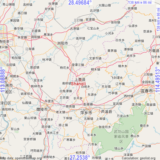
Shangli GPS coordinates[2]
27° 52' 37.56" North, 113° 47' 31.2" East
| Map corner | latitude | longitude |
|---|---|---|
| Upper-left | 28.49684°, | 113.08888° |
| Center: | 27.8771°, | 113.792° |
| Lower-right: | 27.2538°, | 114.49513° |
| Map W x H: | 138.2×138.2 km | = 85.9×85.9mi |
| max Lat: | 53.31946° ⇑74.8% North |
| Shangli: | 27.8771° |
| min Lat: | ⇓25.2% South 18.22056° |
| min Long | Shangli | max Long |
| 75.07348° | 113.792° | 134.28917° |
| W 47.4%⇐ | ⇒52.6% E |
Elevation
Elevation of Shangli is 90 m = 295 ft, and this is 394.8 m = 1295 ft below average elevation for this country.
| Max E: |
5622 m = 18445 ft | 61.5% |
| Avg. | 484.8 m = 1591 ft | |
| Shangli | 90 m = 295 ft | |
Min E: |
-3 m = -10 ft | 38.5% |
See also: China elevation on elevation.city.
Geographical zone
Shangli is located in North temperate zone (between Tropic of Cancer and the Arctic Circle). Distance of this Northern Tropic circle is 493.7 km =306.8 mi to South.| Distance of | km | miles | from Shangli |
|---|---|---|---|
| North Pole | 6907.4 | 4292.1 | to North |
| Arctic Circle | 4301.5 | 2672.8 | to North |
| Tropic Cancer | 493.7 | 306.8 | to South |
| Equator | 3099.6 | 1926 | to South |


Nearby cities:
15 places around Shangli: (largest is in red/bold)
• Cihua
27.6 km =17.1 mi,  56°
56°
• Feijiantan
31.8 km =19.8 mi,  86°
86°
• Guankou
35.2 km =21.9 mi,  332°
332°
• Huangmao
37.6 km =23.4 mi,  47°
47°
• Luxi
35.9 km =22.3 mi,  138°
138°
• Pingxiang
29.6 km =18.4 mi,  168°
168°
• Raoshi
34.7 km =21.6 mi, 94°
• Tiantai
23 km =14.3 mi,  103°
103°
• Tiantaishan
20.5 km =12.7 mi, 87°
• Xiangdong
25.9 km =16.1 mi,  194°
194°
• Xishan
37.1 km =23.1 mi,  230°
230°
• Xuanfeng
38 km =23.6 mi,  121°
121°
• Yinhe
37.6 km =23.4 mi, 121°
• Yuannan
32.9 km =20.4 mi,  134°
134°
• Zhuting
30.3 km =18.8 mi,  111°
111°
Sources, notices
• [Note1] Compared only with cities in China existing in our database
• [Src1] Map data: © OpenStreetMap contributors (CC-BY-SA)
• [Src2] Other city data from geonames.org with taken over terms of usage.
• [Src3] Geographical zone / Annual Mean Temperature by Robert A. Rohde @ Wikipedia
