Penglai geodata
Penglai (Hainan) is a seat of a fourth-order administrative division; located in China in Asia/Shanghai (GMT+8) time zone. In our database, there are 1268 cities with bigger population. Compared to other cities in China, 99.2% of cities are located further ↑North; 69% of cities are located further →East and 51% of cities have higher elevation than Penglai. Note1


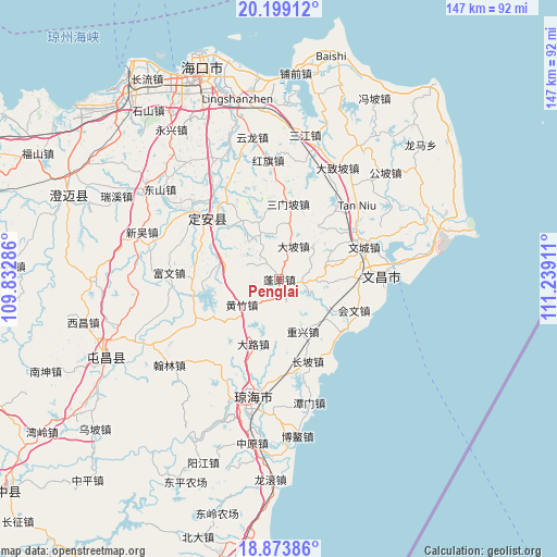
Penglai GPS coordinates[2]
19° 32' 16.26" North, 110° 32' 9.528" East
| Map corner | latitude | longitude |
|---|---|---|
| Upper-left | 20.19912°, | 109.83286° |
| Center: | 19.53785°, | 110.53598° |
| Lower-right: | 18.87386°, | 111.23911° |
| Map W x H: | 147.4×147.4 km | = 91.6×91.6mi |
| max Lat: | 53.31946° ⇑99.2% North |
| Penglai: | 19.53785° |
| min Lat: | ⇓0.8% South 18.22056° |
| min Long | Penglai | max Long |
| 75.07348° | 110.53598° | 134.28917° |
| W 31%⇐ | ⇒69% E |
Elevation
Elevation of Penglai is 156 m = 512 ft, and this is 328.8 m = 1079 ft below average elevation for this country.
| Max E: |
5622 m = 18445 ft | 51% |
| Avg. | 484.8 m = 1591 ft | |
| Penglai | 156 m = 512 ft | |
Min E: |
-3 m = -10 ft | 49% |
See also: China elevation on elevation.city.
Geographical zone
Penglai is located in North Torrid zone (between Equator and Tropic of Cancer). Distance of this Northern Tropic circle is 433.5 km =269.4 mi to North.| Distance of | km | miles | from Penglai |
|---|---|---|---|
| North Pole | 7834.7 | 4868.3 | to North |
| Arctic Circle | 5228.8 | 3249 | to North |
| Tropic Cancer | 433.5 | 269.4 | to North |
| Equator | 2172.4 | 1349.9 | to South |


Nearby cities:
15 places around Penglai: (largest is in red/bold)
• Changpo
22.9 km =14.2 mi,  160°
160°
• Chongxing
15.2 km =9.4 mi, 155°
• Dalu
18.1 km =11.2 mi,  204°
204°
• Dapo
9.5 km =5.9 mi,  23°
23°
• Dingcheng
24 km =14.9 mi,  310°
310°
• Donglu
26.8 km =16.7 mi,  33°
33°
• Huangzhu
12.1 km =7.5 mi,  237°
237°
• Huiwen
21.4 km =13.3 mi,  112°
112°
• Jiazi
9.1 km =5.7 mi,  331°
331°
• Leiming
22.7 km =14.1 mi,  275°
275°
• Longhu
15.5 km =9.6 mi,  286°
286°
• Longmen
24.5 km =15.2 mi, 244°
• Sanmenpo
20 km =12.4 mi,  6°
6°
• Tayang
27.6 km =17.1 mi,  186°
186°
• Wenchang
23.9 km =14.9 mi,  68°
68°
Sources, notices
• [Note1] Compared only with cities in China existing in our database
• [Src1] Map data: © OpenStreetMap contributors (CC-BY-SA)
• [Src2] Other city data from geonames.org with taken over terms of usage.
• [Src3] Geographical zone / Annual Mean Temperature by Robert A. Rohde @ Wikipedia
