Donglu geodata
Donglu (Hainan) is a seat of a fourth-order administrative division; located in China in Asia/Shanghai (GMT+8) time zone. In our database, there are 1268 cities with bigger population. Compared to other cities in China, 99% of cities are located further ↑North; 68.4% of cities are located further →East and 73% of cities have higher elevation than Donglu. Note1


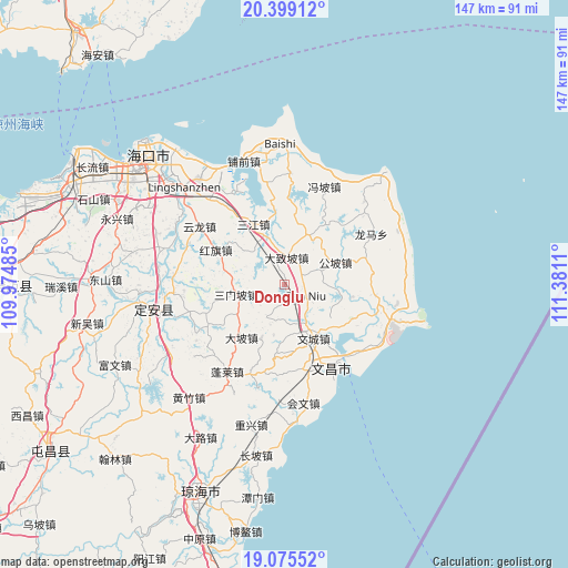
Donglu GPS coordinates[2]
19° 44' 19.284" North, 110° 40' 40.692" East
| Map corner | latitude | longitude |
|---|---|---|
| Upper-left | 20.39912°, | 109.97485° |
| Center: | 19.73869°, | 110.67797° |
| Lower-right: | 19.07552°, | 111.3811° |
| Map W x H: | 147.2×147.2 km | = 91.5×91.5mi |
| max Lat: | 53.31946° ⇑99% North |
| Donglu: | 19.73869° |
| min Lat: | ⇓1% South 18.22056° |
| min Long | Donglu | max Long |
| 75.07348° | 110.67797° | 134.28917° |
| W 31.6%⇐ | ⇒68.4% E |
Elevation
Elevation of Donglu is 42 m = 138 ft, and this is 442.8 m = 1453 ft below average elevation for this country.
| Max E: |
5622 m = 18445 ft | 73% |
| Avg. | 484.8 m = 1591 ft | |
| Donglu | 42 m = 138 ft | |
Min E: |
-3 m = -10 ft | 27% |
See also: China elevation on elevation.city.
Geographical zone
Donglu is located in North Torrid zone (between Equator and Tropic of Cancer). Distance of this Northern Tropic circle is 411.2 km =255.5 mi to North.| Distance of | km | miles | from Donglu |
|---|---|---|---|
| North Pole | 7812.3 | 4854.3 | to North |
| Arctic Circle | 5206.4 | 3235.1 | to North |
| Tropic Cancer | 411.2 | 255.5 | to North |
| Equator | 2194.7 | 1363.7 | to South |


Nearby cities:
15 places around Donglu: (largest is in red/bold)
• Baoluo
13.4 km =8.3 mi,  31°
31°
• Changsa
23.2 km =14.4 mi,  83°
83°
• Dapo
17.6 km =10.9 mi,  219°
219°
• Dazhipo
7.2 km =4.5 mi,  3°
3°
• Dongge
19.6 km =12.2 mi,  116°
116°
• Dongjiao
25.9 km =16.1 mi,  133°
133°
• Gongpo
14.4 km =8.9 mi,  65°
65°
• Hongqi
20.1 km =12.5 mi,  296°
296°
• Jiazi
24 km =14.9 mi,  233°
233°
• Penglai
26.8 km =16.7 mi,  213°
213°
• Sanjiang
17.7 km =11 mi,  332°
332°
• Sanmenpo
12.8 km =8 mi,  258°
258°
• Tanniu
6.3 km =3.9 mi, 118°
• Wenchang
15.6 km =9.7 mi,  151°
151°
• Wenjiao
25.1 km =15.6 mi,  107°
107°
Sources, notices
• [Note1] Compared only with cities in China existing in our database
• [Src1] Map data: © OpenStreetMap contributors (CC-BY-SA)
• [Src2] Other city data from geonames.org with taken over terms of usage.
• [Src3] Geographical zone / Annual Mean Temperature by Robert A. Rohde @ Wikipedia
