Wenchang geodata
Wenchang (Hainan) is a seat of a third-order administrative division; located in China in Asia/Shanghai (GMT+8) time zone. With population of 115,000 people, there are 378 cities with bigger population in this country. Compared to other cities in China, 99.1% of cities are located further ↑North; 68.1% of cities are located further →East and 86.9% of cities have higher elevation than Wenchang. Note1


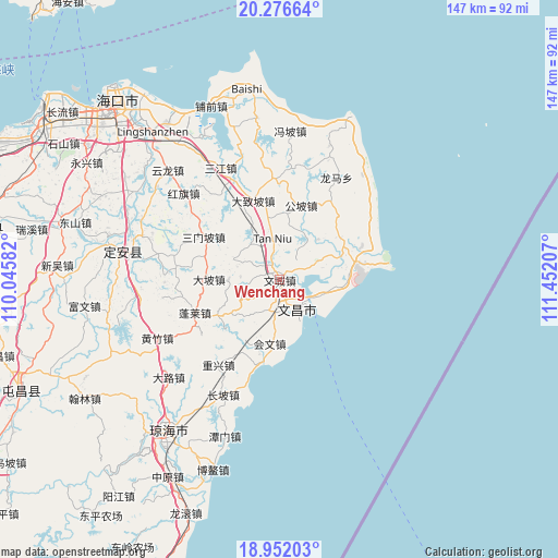
Wenchang GPS coordinates[2]
19° 36' 56.52" North, 110° 44' 56.184" East
| Map corner | latitude | longitude |
|---|---|---|
| Upper-left | 20.27664°, | 110.04582° |
| Center: | 19.6157°, | 110.74894° |
| Lower-right: | 18.95203°, | 111.45207° |
| Map W x H: | 147.3×147.3 km | = 91.5×91.5mi |
| max Lat: | 53.31946° ⇑99.1% North |
| Wenchang: | 19.6157° |
| min Lat: | ⇓0.9% South 18.22056° |
| min Long | Wenchang | max Long |
| 75.07348° | 110.74894° | 134.28917° |
| W 31.9%⇐ | ⇒68.1% E |
Elevation
Elevation of Wenchang is 13 m = 43 ft, and this is 471.8 m = 1548 ft below average elevation for this country.
| Max E: |
5622 m = 18445 ft | 86.9% |
| Avg. | 484.8 m = 1591 ft | |
| Wenchang | 13 m = 43 ft | |
Min E: |
-3 m = -10 ft | 13.1% |
See also: Wenchang elevation on elevation.city.
Geographical zone
Wenchang is located in North Torrid zone (between Equator and Tropic of Cancer). Distance of this Northern Tropic circle is 424.9 km =264 mi to North.| Distance of | km | miles | from Wenchang |
|---|---|---|---|
| North Pole | 7826 | 4862.8 | to North |
| Arctic Circle | 5220.1 | 3243.6 | to North |
| Tropic Cancer | 424.9 | 264 | to North |
| Equator | 2181.1 | 1355.3 | to South |


Nearby cities:
15 places around Wenchang: (largest is in red/bold)
• Baoluo
25.1 km =15.6 mi,  358°
358°
• Changsa
22.6 km =14 mi,  43°
43°
• Dapo
18.6 km =11.6 mi,  270°
270°
• Dazhipo
22 km =13.7 mi,  341°
341°
• Dongge
11.2 km =7 mi,  63°
63°
• Dongjiao
12 km =7.5 mi,  110°
110°
• Donglu
15.6 km =9.7 mi,  331°
331°
• Gongpo
20.4 km =12.7 mi,  16°
16°
• Huiwen
17.1 km =10.6 mi,  188°
188°
• Jiazi
26.7 km =16.6 mi, 268°
• Longlou
23 km =14.3 mi,  78°
78°
• Penglai
23.9 km =14.9 mi,  248°
248°
• Sanmenpo
22.9 km =14.2 mi,  299°
299°
• Tanniu
10.8 km =6.7 mi,  350°
350°
• Wenjiao
17.6 km =10.9 mi,  69°
69°
Sources, notices
• [Note1] Compared only with cities in China existing in our database
• [Src1] Map data: © OpenStreetMap contributors (CC-BY-SA)
• [Src2] Other city data from geonames.org with taken over terms of usage.
• [Src3] Geographical zone / Annual Mean Temperature by Robert A. Rohde @ Wikipedia
