Pantang geodata
Pantang (Hubei) is a seat of a fourth-order administrative division; located in China in Asia/Shanghai (GMT+8) time zone. In our database, there are 1268 cities with bigger population. Compared to other cities in China, 54.8% of cities are located further ↓South; 53.6% of cities are located further ←West and 67.2% of cities have higher elevation than Pantang. Note1


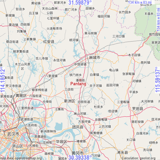
Pantang GPS coordinates[2]
30° 59' 52.764" North, 114° 53' 17.664" East
| Map corner | latitude | longitude |
|---|---|---|
| Upper-left | 31.59879°, | 114.18512° |
| Center: | 30.99799°, | 114.88824° |
| Lower-right: | 30.39338°, | 115.59137° |
| Map W x H: | 134×134 km | = 83.3×83.3mi |
| max Lat: | 53.31946° ⇑45.2% North |
| Pantang: | 30.99799° |
| min Lat: | ⇓54.8% South 18.22056° |
| min Long | Pantang | max Long |
| 75.07348° | 114.88824° | 134.28917° |
| W 53.6%⇐ | ⇒46.4% E |
Elevation
Elevation of Pantang is 64 m = 210 ft, and this is 420.8 m = 1381 ft below average elevation for this country.
| Max E: |
5622 m = 18445 ft | 67.2% |
| Avg. | 484.8 m = 1591 ft | |
| Pantang | 64 m = 210 ft | |
Min E: |
-3 m = -10 ft | 32.8% |
See also: China elevation on elevation.city.
Geographical zone
Pantang is located in North temperate zone (between Tropic of Cancer and the Arctic Circle). Distance of this Northern Tropic circle is 840.7 km =522.4 mi to South.| Distance of | km | miles | from Pantang |
|---|---|---|---|
| North Pole | 6560.4 | 4076.4 | to North |
| Arctic Circle | 3954.5 | 2457.2 | to North |
| Tropic Cancer | 840.7 | 522.4 | to South |
| Equator | 3446.7 | 2141.7 | to South |


Nearby cities:
15 places around Pantang: (largest is in red/bold)
• Baiguo
12.9 km =8 mi,  68°
68°
• Fuzihe
13.7 km =8.5 mi,  108°
108°
• Gulou
24.4 km =15.2 mi,  34°
34°
• Jiujie
18.4 km =11.4 mi,  170°
170°
• Macheng
23.9 km =14.9 mi, 32°
• Nanhu
21.7 km =13.5 mi, 28°
• Qiting
14 km =8.7 mi,  277°
277°
• Sandian
11.8 km =7.3 mi,  230°
230°
• Songbu
11.6 km =7.2 mi,  308°
308°
• Taipingqiao
23.9 km =14.9 mi,  260°
260°
• Tiemengang
6.1 km =3.8 mi,  319°
319°
• Xinzhou
16.9 km =10.5 mi,  209°
209°
• Xiyang
22.2 km =13.8 mi,  353°
353°
• Xugu
9.2 km =5.7 mi,  124°
124°
• Zhongguanyi
13.5 km =8.4 mi,  0°
0°
Sources, notices
• [Note1] Compared only with cities in China existing in our database
• [Src1] Map data: © OpenStreetMap contributors (CC-BY-SA)
• [Src2] Other city data from geonames.org with taken over terms of usage.
• [Src3] Geographical zone / Annual Mean Temperature by Robert A. Rohde @ Wikipedia
