Nanhu geodata
Nanhu (Hubei) is a seat of a fourth-order administrative division; located in China in Asia/Shanghai (GMT+8) time zone. In our database, there are 1268 cities with bigger population. Compared to other cities in China, 56% of cities are located further ↓South; 54.3% of cities are located further ←West and 63.5% of cities have higher elevation than Nanhu. Note1


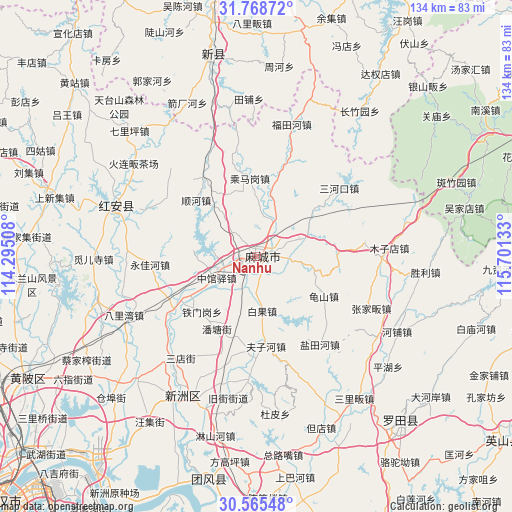
Nanhu GPS coordinates[2]
31° 10' 8.436" North, 114° 59' 53.52" East
| Map corner | latitude | longitude |
|---|---|---|
| Upper-left | 31.76872°, | 114.29508° |
| Center: | 31.16901°, | 114.9982° |
| Lower-right: | 30.56548°, | 115.70133° |
| Map W x H: | 133.8×133.8 km | = 83.1×83.1mi |
| max Lat: | 53.31946° ⇑44% North |
| Nanhu: | 31.16901° |
| min Lat: | ⇓56% South 18.22056° |
| min Long | Nanhu | max Long |
| 75.07348° | 114.9982° | 134.28917° |
| W 54.3%⇐ | ⇒45.7% E |
Elevation
Elevation of Nanhu is 80 m = 262 ft, and this is 404.8 m = 1328 ft below average elevation for this country.
| Max E: |
5622 m = 18445 ft | 63.5% |
| Avg. | 484.8 m = 1591 ft | |
| Nanhu | 80 m = 262 ft | |
Min E: |
-3 m = -10 ft | 36.5% |
See also: China elevation on elevation.city.
Geographical zone
Nanhu is located in North temperate zone (between Tropic of Cancer and the Arctic Circle). Distance of this Northern Tropic circle is 859.8 km =534.3 mi to South.| Distance of | km | miles | from Nanhu |
|---|---|---|---|
| North Pole | 6541.4 | 4064.6 | to North |
| Arctic Circle | 3935.5 | 2445.4 | to North |
| Tropic Cancer | 859.8 | 534.3 | to South |
| Equator | 3465.7 | 2153.5 | to South |


Nearby cities:
15 places around Nanhu: (largest is in red/bold)
• Baiguo
14.3 km =8.9 mi,  173°
173°
• Chengmagang
20.5 km =12.7 mi,  355°
355°
• Fuzihe
23.6 km =14.7 mi, 173°
• Guishan
20.3 km =12.6 mi,  120°
120°
• Gulou
3.6 km =2.2 mi,  73°
73°
• Longchiqiao
3.1 km =1.9 mi,  46°
46°
• Macheng
2.6 km =1.6 mi,  61°
61°
• Pantang
21.7 km =13.5 mi,  208°
208°
• Shunhe
22 km =13.7 mi,  312°
312°
• Songbu
22.8 km =14.2 mi,  238°
238°
• Tiemengang
20.3 km =12.6 mi,  225°
225°
• Xiyang
13.5 km =8.4 mi,  283°
283°
• Xugu
24.4 km =15.2 mi,  186°
186°
• Yanjiahe
12.1 km =7.5 mi, 68°
• Zhongguanyi
11.8 km =7.3 mi, 242°
Sources, notices
• [Note1] Compared only with cities in China existing in our database
• [Src1] Map data: © OpenStreetMap contributors (CC-BY-SA)
• [Src2] Other city data from geonames.org with taken over terms of usage.
• [Src3] Geographical zone / Annual Mean Temperature by Robert A. Rohde @ Wikipedia
