Gulou geodata
Gulou (Hubei) is a seat of a fourth-order administrative division; located in China in Asia/Shanghai (GMT+8) time zone. In our database, there are 1268 cities with bigger population. Compared to other cities in China, 56.1% of cities are located further ↓South; 54.5% of cities are located further ←West and 68.4% of cities have higher elevation than Gulou. Note1


Gulou GPS coordinates[2]
31° 10' 41.88" North, 115° 2' 5.1" East
| Map corner | latitude | longitude |
|---|---|---|
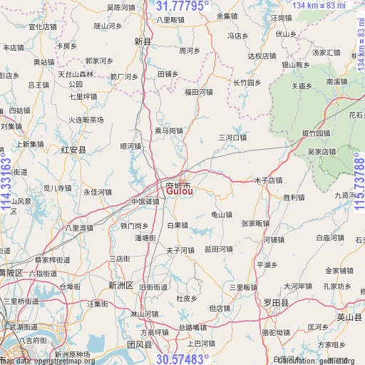
| Upper-left | 31.77795°, | 114.33163° |
| Center: | 31.1783°, | 115.03475° |
| Lower-right: | 30.57483°, | 115.73788° |
| Map W x H: | 133.8×133.8 km | = 83.1×83.1mi |
| max Lat: | 53.31946° ⇑43.9% North |
| Gulou: | 31.1783° |
| min Lat: | ⇓56.1% South 18.22056° |
| min Long | Gulou | max Long |
| 75.07348° | 115.03475° | 134.28917° |
| W 54.5%⇐ | ⇒45.5% E |
Elevation
Elevation of Gulou is 58 m = 190 ft, and this is 426.8 m = 1400 ft below average elevation for this country.
| Max E: |
5622 m = 18445 ft | 68.4% |
| Avg. | 484.8 m = 1591 ft | |
| Gulou | 58 m = 190 ft | |
Min E: |
-3 m = -10 ft | 31.6% |
See also: China elevation on elevation.city.
Geographical zone
Gulou is located in North temperate zone (between Tropic of Cancer and the Arctic Circle). Distance of this Northern Tropic circle is 860.8 km =534.9 mi to South.| Distance of | km | miles | from Gulou |
|---|---|---|---|
| North Pole | 6540.4 | 4064 | to North |
| Arctic Circle | 3934.5 | 2444.8 | to North |
| Tropic Cancer | 860.8 | 534.9 | to South |
| Equator | 3466.7 | 2154.1 | to South |


Nearby cities:
15 places around Gulou: (largest is in red/bold)
• Baiguo
15.4 km =9.6 mi,  187°
187°
• Chengmagang
20.1 km =12.5 mi,  344°
344°
• Fuzihe
24.5 km =15.2 mi,  182°
182°
• Guishan
18.1 km =11.2 mi,  129°
129°
• Huangtugang
23.2 km =14.4 mi,  9°
9°
• Longchiqiao
1.6 km =1 mi,  310°
310°
• Macheng
1.2 km =0.7 mi,  279°
279°
• Nanhu
3.6 km =2.2 mi,  253°
253°
• Pantang
24.4 km =15.2 mi,  214°
214°
• Sanhekou
24.8 km =15.4 mi,  47°
47°
• Shunhe
24 km =14.9 mi,  304°
304°
• Tiemengang
23.6 km =14.7 mi,  229°
229°
• Xiyang
16.7 km =10.4 mi, 276°
• Yanjiahe
8.5 km =5.3 mi,  65°
65°
• Zhongguanyi
15.4 km =9.6 mi,  244°
244°
Sources, notices
• [Note1] Compared only with cities in China existing in our database
• [Src1] Map data: © OpenStreetMap contributors (CC-BY-SA)
• [Src2] Other city data from geonames.org with taken over terms of usage.
• [Src3] Geographical zone / Annual Mean Temperature by Robert A. Rohde @ Wikipedia
