Nanxiang geodata
Nanxiang (Shanghai) is a seat of a fourth-order administrative division; located in China in Asia/Shanghai (GMT+8) time zone. In our database, there are 1268 cities with bigger population. Compared to other cities in China, 57% of cities are located further ↓South; 89.2% of cities are located further ←West and 97.2% of cities have higher elevation than Nanxiang. Note1


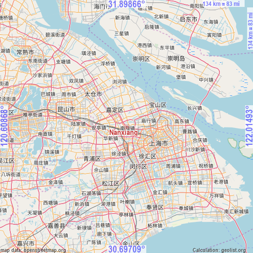
Nanxiang GPS coordinates[2]
31° 17' 59.244" North, 121° 18' 42.48" East
| Map corner | latitude | longitude |
|---|---|---|
| Upper-left | 31.89866°, | 120.60868° |
| Center: | 31.29979°, | 121.3118° |
| Lower-right: | 30.69709°, | 122.01493° |
| Map W x H: | 133.6×133.6 km | = 83×83mi |
| max Lat: | 53.31946° ⇑43% North |
| Nanxiang: | 31.29979° |
| min Lat: | ⇓57% South 18.22056° |
| min Long | Nanxiang | max Long |
| 75.07348° | 121.3118° | 134.28917° |
| W 89.2%⇐ | ⇒10.8% E |
Elevation
Elevation of Nanxiang is 5 m = 16 ft, and this is 479.8 m = 1574 ft below average elevation for this country.
| Max E: |
5622 m = 18445 ft | 97.2% |
| Avg. | 484.8 m = 1591 ft | |
| Nanxiang | 5 m = 16 ft | |
Min E: |
-3 m = -10 ft | 2.8% |
See also: China elevation on elevation.city.
Geographical zone
Nanxiang is located in North temperate zone (between Tropic of Cancer and the Arctic Circle). Distance of this Northern Tropic circle is 874.3 km =543.3 mi to South.| Distance of | km | miles | from Nanxiang |
|---|---|---|---|
| North Pole | 6526.9 | 4055.6 | to North |
| Arctic Circle | 3921 | 2436.4 | to North |
| Tropic Cancer | 874.3 | 543.3 | to South |
| Equator | 3480.2 | 2162.5 | to South |


Nearby cities:
15 places around Nanxiang: (largest is in red/bold)
• Anting
14.7 km =9.1 mi,  269°
269°
• Changning
13.8 km =8.6 mi,  131°
131°
• Changzheng
8.6 km =5.3 mi,  141°
141°
• Huacao
10.6 km =6.6 mi,  192°
192°
• Huangdu
10.2 km =6.3 mi,  255°
255°
• Huaxin
10.7 km =6.6 mi,  236°
236°
• Jiadingzhen
11.5 km =7.1 mi,  326°
326°
• Jiangqiao
6.9 km =4.3 mi,  169°
169°
• Malu
8.7 km =5.4 mi,  348°
348°
• Waigang
15.1 km =9.4 mi,  297°
297°
• Xinchenglu
10.9 km =6.8 mi, 334°
• Xuhang
13.2 km =8.2 mi,  342°
342°
• Xujing
14.3 km =8.9 mi,  195°
195°
• Zhabei
14.8 km =9.2 mi,  108°
108°
• Zhenxin
7.2 km =4.5 mi,  146°
146°
Sources, notices
• [Note1] Compared only with cities in China existing in our database
• [Src1] Map data: © OpenStreetMap contributors (CC-BY-SA)
• [Src2] Other city data from geonames.org with taken over terms of usage.
• [Src3] Geographical zone / Annual Mean Temperature by Robert A. Rohde @ Wikipedia
