Anting geodata
Anting (Shanghai) is a seat of a fourth-order administrative division; located in China in Asia/Shanghai (GMT+8) time zone. In our database, there are 1268 cities with bigger population. Compared to other cities in China, 57% of cities are located further ↓South; 88.4% of cities are located further ←West and 92.7% of cities have higher elevation than Anting. Note1


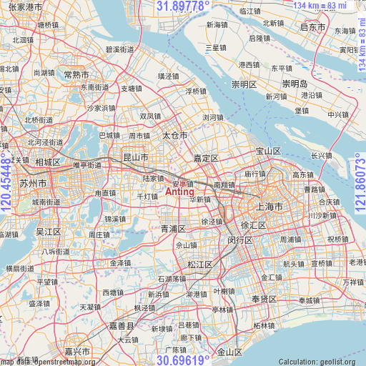
Anting GPS coordinates[2]
31° 17' 56.04" North, 121° 9' 27.36" East
| Map corner | latitude | longitude |
|---|---|---|
| Upper-left | 31.89778°, | 120.45448° |
| Center: | 31.2989°, | 121.1576° |
| Lower-right: | 30.69619°, | 121.86073° |
| Map W x H: | 133.6×133.6 km | = 83×83mi |
| max Lat: | 53.31946° ⇑43% North |
| Anting: | 31.2989° |
| min Lat: | ⇓57% South 18.22056° |
| min Long | Anting | max Long |
| 75.07348° | 121.1576° | 134.28917° |
| W 88.4%⇐ | ⇒11.6% E |
Elevation
Elevation of Anting is 8 m = 26 ft, and this is 476.8 m = 1564 ft below average elevation for this country.
| Max E: |
5622 m = 18445 ft | 92.7% |
| Avg. | 484.8 m = 1591 ft | |
| Anting | 8 m = 26 ft | |
Min E: |
-3 m = -10 ft | 7.3% |
See also: China elevation on elevation.city.
Geographical zone
Anting is located in North temperate zone (between Tropic of Cancer and the Arctic Circle). Distance of this Northern Tropic circle is 874.2 km =543.2 mi to South.| Distance of | km | miles | from Anting |
|---|---|---|---|
| North Pole | 6527 | 4055.7 | to North |
| Arctic Circle | 3921.1 | 2436.5 | to North |
| Tropic Cancer | 874.2 | 543.2 | to South |
| Equator | 3480.1 | 2162.4 | to South |


Nearby cities:
15 places around Anting: (largest is in red/bold)
• Baihe
5.2 km =3.2 mi,  202°
202°
• Chonggu
10.7 km =6.6 mi,  173°
173°
• Huacao
16 km =9.9 mi,  129°
129°
• Huangdu
5.4 km =3.4 mi,  117°
117°
• Huaqiao
6.9 km =4.3 mi,  272°
272°
• Huaxin
8.2 km =5.1 mi,  135°
135°
• Jiadingzhen
12.7 km =7.9 mi,  40°
40°
• Lujia
11 km =6.8 mi,  279°
279°
• Malu
15.6 km =9.7 mi,  56°
56°
• Nanxiang
14.7 km =9.1 mi,  89°
89°
• Qiandeng
15.7 km =9.8 mi,  256°
256°
• Waigang
7.2 km =4.5 mi,  9°
9°
• Xianghuaqiao
14.4 km =8.9 mi, 195°
• Xinchenglu
14.1 km =8.8 mi,  45°
45°
• Xuhang
16.6 km =10.3 mi, 40°
Sources, notices
• [Note1] Compared only with cities in China existing in our database
• [Src1] Map data: © OpenStreetMap contributors (CC-BY-SA)
• [Src2] Other city data from geonames.org with taken over terms of usage.
• [Src3] Geographical zone / Annual Mean Temperature by Robert A. Rohde @ Wikipedia
