Xinchenglu geodata
Xinchenglu (Shanghai) is a seat of a third-order administrative division; located in China in Asia/Shanghai (GMT+8) time zone. In our database, there are 1268 cities with bigger population. Compared to other cities in China, 57.6% of cities are located further ↓South; 88.9% of cities are located further ←West and 92.7% of cities have higher elevation than Xinchenglu. Note1


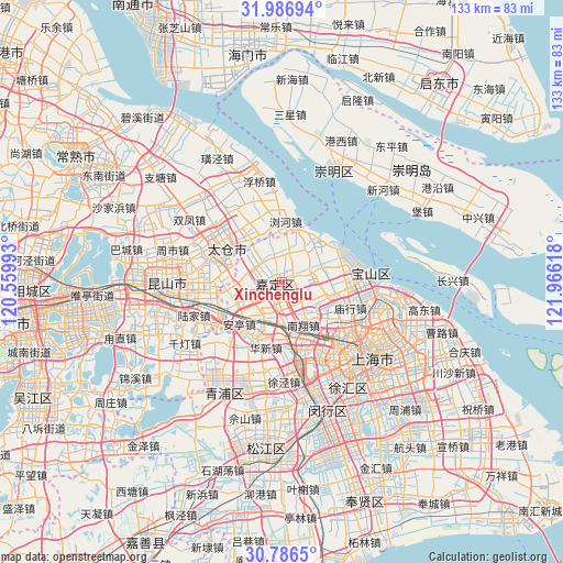
Xinchenglu GPS coordinates[2]
31° 23' 19.104" North, 121° 15' 46.98" East
| Map corner | latitude | longitude |
|---|---|---|
| Upper-left | 31.98694°, | 120.55993° |
| Center: | 31.38864°, | 121.26305° |
| Lower-right: | 30.7865°, | 121.96618° |
| Map W x H: | 133.5×133.5 km | = 83×83mi |
| max Lat: | 53.31946° ⇑42.4% North |
| Xinchenglu: | 31.38864° |
| min Lat: | ⇓57.6% South 18.22056° |
| min Long | Xinchenglu | max Long |
| 75.07348° | 121.26305° | 134.28917° |
| W 88.9%⇐ | ⇒11.1% E |
Elevation
Elevation of Xinchenglu is 8 m = 26 ft, and this is 476.8 m = 1564 ft below average elevation for this country.
| Max E: |
5622 m = 18445 ft | 92.7% |
| Avg. | 484.8 m = 1591 ft | |
| Xinchenglu | 8 m = 26 ft | |
Min E: |
-3 m = -10 ft | 7.3% |
See also: China elevation on elevation.city.
Geographical zone
Xinchenglu is located in North temperate zone (between Tropic of Cancer and the Arctic Circle). Distance of this Northern Tropic circle is 884.2 km =549.4 mi to South.| Distance of | km | miles | from Xinchenglu |
|---|---|---|---|
| North Pole | 6517 | 4049.5 | to North |
| Arctic Circle | 3911.1 | 2430.2 | to North |
| Tropic Cancer | 884.2 | 549.4 | to South |
| Equator | 3490.1 | 2168.6 | to South |


Nearby cities:
15 places around Xinchenglu: (largest is in red/bold)
• Anting
14.1 km =8.8 mi,  225°
225°
• Chengxiang
17.3 km =10.7 mi,  292°
292°
• Huangdu
13.5 km =8.4 mi,  202°
202°
• Huating
8.6 km =5.3 mi,  343°
343°
• Huaxin
16.3 km =10.1 mi, 195°
• Jiadingzhen
1.8 km =1.1 mi,  259°
259°
• Jiangqiao
17.6 km =10.9 mi,  160°
160°
• Liuhe
13.3 km =8.3 mi,  359°
359°
• Ludu
11.9 km =7.4 mi,  321°
321°
• Luojing
12.3 km =7.6 mi,  35°
35°
• Malu
3.2 km =2 mi,  114°
114°
• Nanxiang
10.9 km =6.8 mi,  154°
154°
• Waigang
9.2 km =5.7 mi,  252°
252°
• Xuhang
2.8 km =1.7 mi,  14°
14°
• Zhenxin
18.1 km =11.2 mi, 151°
Sources, notices
• [Note1] Compared only with cities in China existing in our database
• [Src1] Map data: © OpenStreetMap contributors (CC-BY-SA)
• [Src2] Other city data from geonames.org with taken over terms of usage.
• [Src3] Geographical zone / Annual Mean Temperature by Robert A. Rohde @ Wikipedia
