Zhabei geodata
Zhabei (Shanghai) is a section of populated place; located in China in Asia/Shanghai (GMT+8) time zone. With population of 840,000 people, there are 74 cities with bigger population in this country. Compared to other cities in China, 56.7% of cities are located further ↓South; 89.9% of cities are located further ←West and 89.9% of cities have higher elevation than Zhabei. Note1


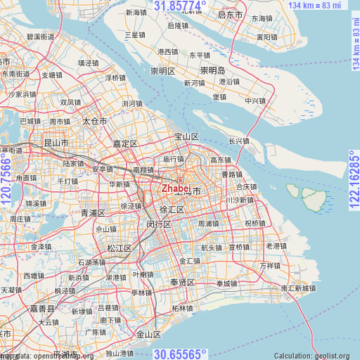
Zhabei GPS coordinates[2]
31° 15' 30.996" North, 121° 27' 34.992" East
| Map corner | latitude | longitude |
|---|---|---|
| Upper-left | 31.85774°, | 120.7566° |
| Center: | 31.25861°, | 121.45972° |
| Lower-right: | 30.65565°, | 122.16285° |
| Map W x H: | 133.7×133.7 km | = 83.1×83.1mi |
| max Lat: | 53.31946° ⇑43.3% North |
| Zhabei: | 31.25861° |
| min Lat: | ⇓56.7% South 18.22056° |
| min Long | Zhabei | max Long |
| 75.07348° | 121.45972° | 134.28917° |
| W 89.9%⇐ | ⇒10.1% E |
Elevation
Elevation of Zhabei is 10 m = 33 ft, and this is 474.8 m = 1558 ft below average elevation for this country.
| Max E: |
5622 m = 18445 ft | 89.9% |
| Avg. | 484.8 m = 1591 ft | |
| Zhabei | 10 m = 33 ft | |
Min E: |
-3 m = -10 ft | 10.1% |
See also: Zhabei elevation on elevation.city.
Geographical zone
Zhabei is located in North temperate zone (between Tropic of Cancer and the Arctic Circle). Distance of this Northern Tropic circle is 869.7 km =540.4 mi to South.| Distance of | km | miles | from Zhabei |
|---|---|---|---|
| North Pole | 6531.4 | 4058.4 | to North |
| Arctic Circle | 3925.5 | 2439.2 | to North |
| Tropic Cancer | 869.7 | 540.4 | to South |
| Equator | 3475.6 | 2159.6 | to South |


Nearby cities:
15 places around Zhabei: (largest is in red/bold)
• Baoshan
16.9 km =10.5 mi,  9°
9°
• Changning
5.9 km =3.7 mi,  218°
218°
• Changqiao
13.2 km =8.2 mi,  190°
190°
• Changzheng
9 km =5.6 mi,  256°
256°
• Hongkou
3 km =1.9 mi,  108°
108°
• Huacao
17.4 km =10.8 mi,  250°
250°
• Huamu
9.6 km =6 mi,  123°
123°
• Jiangqiao
13 km =8.1 mi, 260°
• Luwan
5.5 km =3.4 mi,  176°
176°
• Nanxiang
14.8 km =9.2 mi,  288°
288°
• Pudong
7 km =4.3 mi, 112°
• Shanghai
4 km =2.5 mi, 182°
• Xuhui
7.1 km =4.4 mi, 189°
• Yangpu
5.7 km =3.5 mi,  86°
86°
• Zhenxin
10.1 km =6.3 mi, 262°
Sources, notices
• [Note1] Compared only with cities in China existing in our database
• [Src1] Map data: © OpenStreetMap contributors (CC-BY-SA)
• [Src2] Other city data from geonames.org with taken over terms of usage.
• [Src3] Geographical zone / Annual Mean Temperature by Robert A. Rohde @ Wikipedia
