Nankeng geodata
Nankeng (Jiangxi) is a seat of a fourth-order administrative division; located in China in Asia/Shanghai (GMT+8) time zone. In our database, there are 1268 cities with bigger population. Compared to other cities in China, 80.1% of cities are located further ↑North; 58% of cities are located further ←West and 64% of cities have lower elevation than Nankeng. Note1


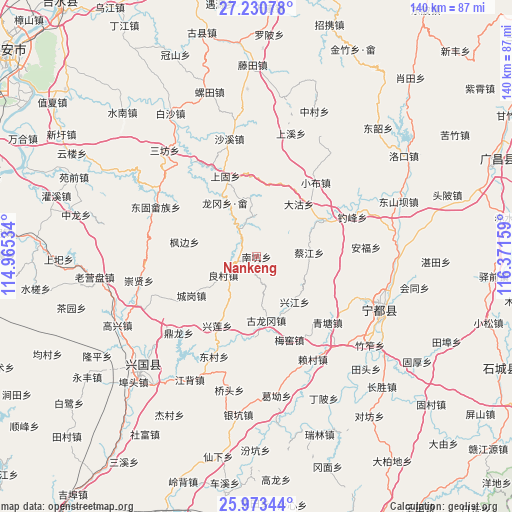
Nankeng GPS coordinates[2]
26° 36' 13.824" North, 115° 40' 6.456" East
| Map corner | latitude | longitude |
|---|---|---|
| Upper-left | 27.23078°, | 114.96534° |
| Center: | 26.60384°, | 115.66846° |
| Lower-right: | 25.97344°, | 116.37159° |
| Map W x H: | 139.8×139.8 km | = 86.9×86.9mi |
| max Lat: | 53.31946° ⇑80.1% North |
| Nankeng: | 26.60384° |
| min Lat: | ⇓19.9% South 18.22056° |
| min Long | Nankeng | max Long |
| 75.07348° | 115.66846° | 134.28917° |
| W 58%⇐ | ⇒42% E |
Elevation
Elevation of Nankeng is 310 m = 1017 ft, and this is 174.8 m = 573 ft below average elevation for this country.
| Max E: |
5622 m = 18445 ft | 36% |
| Avg. | 484.8 m = 1591 ft | |
| Nankeng | 310 m = 1017 ft | |
Min E: |
-3 m = -10 ft | 64% |
See also: China elevation on elevation.city.
Geographical zone
Nankeng is located in North temperate zone (between Tropic of Cancer and the Arctic Circle). Distance of this Northern Tropic circle is 352.2 km =218.8 mi to South.| Distance of | km | miles | from Nankeng |
|---|---|---|---|
| North Pole | 7049 | 4380 | to North |
| Arctic Circle | 4443.1 | 2760.8 | to North |
| Tropic Cancer | 352.2 | 218.8 | to South |
| Equator | 2958.1 | 1838.1 | to South |


Nearby cities:
15 places around Nankeng: (largest is in red/bold)
• Caijiang
14.5 km =9 mi,  85°
85°
• Chenggang
20.9 km =13 mi,  239°
239°
• Dagu
18.6 km =11.6 mi,  38°
38°
• Diaofeng
28.9 km =18 mi,  62°
62°
• Dongcun
29.2 km =18.1 mi,  203°
203°
• Gulonggang
17.6 km =10.9 mi,  170°
170°
• Huangbei
20.4 km =12.7 mi, 61°
• Junbu
11.2 km =7 mi,  358°
358°
• Liangcun
10.5 km =6.5 mi, 241°
• Longgang Shezu
17.2 km =10.7 mi,  330°
330°
• Meiyao
24.5 km =15.2 mi,  158°
158°
• Qingtang
26.5 km =16.5 mi,  133°
133°
• Shanggu
23.6 km =14.7 mi,  338°
338°
• Xiaobu
25.9 km =16.1 mi, 38°
• Xingjiang
16.2 km =10.1 mi,  140°
140°
Sources, notices
• [Note1] Compared only with cities in China existing in our database
• [Src1] Map data: © OpenStreetMap contributors (CC-BY-SA)
• [Src2] Other city data from geonames.org with taken over terms of usage.
• [Src3] Geographical zone / Annual Mean Temperature by Robert A. Rohde @ Wikipedia
