Chenggang geodata
Chenggang (Jiangxi) is a seat of a fourth-order administrative division; located in China in Asia/Shanghai (GMT+8) time zone. In our database, there are 1268 cities with bigger population. Compared to other cities in China, 80.4% of cities are located further ↑North; 56.9% of cities are located further ←West and 64.3% of cities have lower elevation than Chenggang. Note1


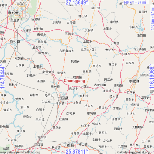
Chenggang GPS coordinates[2]
26° 30' 32.472" North, 115° 29' 15.216" East
| Map corner | latitude | longitude |
|---|---|---|
| Upper-left | 27.13649°, | 114.78444° |
| Center: | 26.50902°, | 115.48756° |
| Lower-right: | 25.87811°, | 116.19069° |
| Map W x H: | 139.9×139.9 km | = 86.9×86.9mi |
| max Lat: | 53.31946° ⇑80.4% North |
| Chenggang: | 26.50902° |
| min Lat: | ⇓19.6% South 18.22056° |
| min Long | Chenggang | max Long |
| 75.07348° | 115.48756° | 134.28917° |
| W 56.9%⇐ | ⇒43.1% E |
Elevation
Elevation of Chenggang is 315 m = 1033 ft, and this is 169.8 m = 557 ft below average elevation for this country.
| Max E: |
5622 m = 18445 ft | 35.7% |
| Avg. | 484.8 m = 1591 ft | |
| Chenggang | 315 m = 1033 ft | |
Min E: |
-3 m = -10 ft | 64.3% |
See also: China elevation on elevation.city.
Geographical zone
Chenggang is located in North temperate zone (between Tropic of Cancer and the Arctic Circle). Distance of this Northern Tropic circle is 341.6 km =212.3 mi to South.| Distance of | km | miles | from Chenggang |
|---|---|---|---|
| North Pole | 7059.5 | 4386.6 | to North |
| Arctic Circle | 4453.6 | 2767.3 | to North |
| Tropic Cancer | 341.6 | 212.3 | to South |
| Equator | 2947.5 | 1831.5 | to South |


Nearby cities:
15 places around Chenggang: (largest is in red/bold)
• Changgang
20 km =12.4 mi,  217°
217°
• Chongxian
15 km =9.3 mi,  287°
287°
• Dinglong
10.9 km =6.8 mi,  197°
197°
• Dongcun
17.5 km =10.9 mi,  158°
158°
• Donggu
25.9 km =16.1 mi,  338°
338°
• Fangtai
10.2 km =6.3 mi,  271°
271°
• Gaoxing
22.1 km =13.7 mi,  247°
247°
• Gulonggang
21.9 km =13.6 mi,  108°
108°
• Jiangbei
23.1 km =14.4 mi,  181°
181°
• Junbu
28 km =17.4 mi,  39°
39°
• Laoyingpan
27.5 km =17.1 mi,  281°
281°
• Liangcun
10.4 km =6.5 mi,  57°
57°
• Longgang Shezu
27.2 km =16.9 mi,  20°
20°
• Nankeng
20.9 km =13 mi, 59°
• Xingjiang
28.4 km =17.6 mi,  94°
94°
Sources, notices
• [Note1] Compared only with cities in China existing in our database
• [Src1] Map data: © OpenStreetMap contributors (CC-BY-SA)
• [Src2] Other city data from geonames.org with taken over terms of usage.
• [Src3] Geographical zone / Annual Mean Temperature by Robert A. Rohde @ Wikipedia
