Dongcun geodata
Dongcun (Jiangxi) is a seat of a fourth-order administrative division; located in China in Asia/Shanghai (GMT+8) time zone. In our database, there are 1268 cities with bigger population. Compared to other cities in China, 80.9% of cities are located further ↑North; 57.3% of cities are located further ←West and 54.5% of cities have lower elevation than Dongcun. Note1


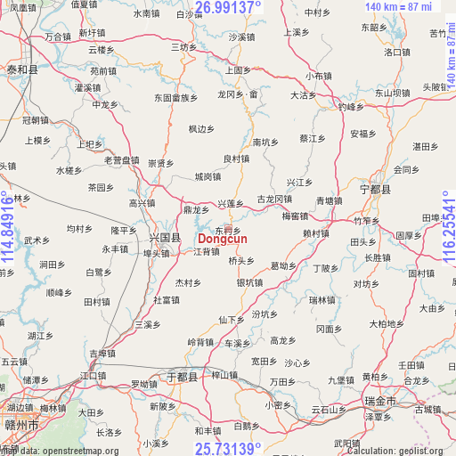
Dongcun GPS coordinates[2]
26° 21' 47.16" North, 115° 33' 8.208" East
| Map corner | latitude | longitude |
|---|---|---|
| Upper-left | 26.99137°, | 114.84916° |
| Center: | 26.3631°, | 115.55228° |
| Lower-right: | 25.73139°, | 116.25541° |
| Map W x H: | 140.1×140.1 km | = 87.1×87.1mi |
| max Lat: | 53.31946° ⇑80.9% North |
| Dongcun: | 26.3631° |
| min Lat: | ⇓19.1% South 18.22056° |
| min Long | Dongcun | max Long |
| 75.07348° | 115.55228° | 134.28917° |
| W 57.3%⇐ | ⇒42.7% E |
Elevation
Elevation of Dongcun is 202 m = 663 ft, and this is 282.8 m = 928 ft below average elevation for this country.
| Max E: |
5622 m = 18445 ft | 45.5% |
| Avg. | 484.8 m = 1591 ft | |
| Dongcun | 202 m = 663 ft | |
Min E: |
-3 m = -10 ft | 54.5% |
See also: China elevation on elevation.city.
Geographical zone
Dongcun is located in North temperate zone (between Tropic of Cancer and the Arctic Circle). Distance of this Northern Tropic circle is 325.4 km =202.2 mi to South.| Distance of | km | miles | from Dongcun |
|---|---|---|---|
| North Pole | 7075.8 | 4396.7 | to North |
| Arctic Circle | 4469.9 | 2777.5 | to North |
| Tropic Cancer | 325.4 | 202.2 | to South |
| Equator | 2931.3 | 1821.4 | to South |


Nearby cities:
15 places around Dongcun: (largest is in red/bold)
• Butou
22.9 km =14.2 mi,  249°
249°
• Changgang
18.6 km =11.6 mi,  270°
270°
• Chenggang
17.5 km =10.9 mi,  338°
338°
• Dinglong
11.3 km =7 mi,  300°
300°
• Fangtai
23.4 km =14.5 mi,  314°
314°
• Ge’ao
20.4 km =12.7 mi,  123°
123°
• Gulonggang
17.2 km =10.7 mi,  56°
56°
• Jiangbei
9.8 km =6.1 mi,  225°
225°
• Jiecun
19.8 km =12.3 mi,  215°
215°
• Laicun
26.6 km =16.5 mi,  93°
93°
• Liangcun
21.9 km =13.6 mi,  6°
6°
• Ma’an
17.2 km =10.7 mi,  181°
181°
• Meiyao
20.8 km =12.9 mi,  79°
79°
• Xingjiang
26.1 km =16.2 mi, 56°
• Yinkeng
17.6 km =10.9 mi,  159°
159°
Sources, notices
• [Note1] Compared only with cities in China existing in our database
• [Src1] Map data: © OpenStreetMap contributors (CC-BY-SA)
• [Src2] Other city data from geonames.org with taken over terms of usage.
• [Src3] Geographical zone / Annual Mean Temperature by Robert A. Rohde @ Wikipedia
