Mi’ersi geodata
Mi’ersi (Hubei) is a seat of a fourth-order administrative division; located in China in Asia/Shanghai (GMT+8) time zone. In our database, there are 1268 cities with bigger population. Compared to other cities in China, 55.2% of cities are located further ↓South; 51.8% of cities are located further ←West and 68.9% of cities have higher elevation than Mi’ersi. Note1


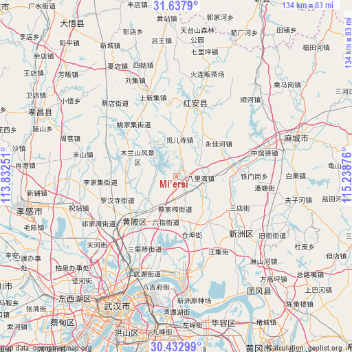
Mi’ersi GPS coordinates[2]
31° 2' 14.46" North, 114° 32' 8.268" East
| Map corner | latitude | longitude |
|---|---|---|
| Upper-left | 31.6379°, | 113.83251° |
| Center: | 31.03735°, | 114.53563° |
| Lower-right: | 30.43299°, | 115.23876° |
| Map W x H: | 134×134 km | = 83.3×83.3mi |
| max Lat: | 53.31946° ⇑44.8% North |
| Mi’ersi: | 31.03735° |
| min Lat: | ⇓55.2% South 18.22056° |
| min Long | Mi’ersi | max Long |
| 75.07348° | 114.53563° | 134.28917° |
| W 51.8%⇐ | ⇒48.2% E |
Elevation
Elevation of Mi’ersi is 56 m = 184 ft, and this is 428.8 m = 1407 ft below average elevation for this country.
| Max E: |
5622 m = 18445 ft | 68.9% |
| Avg. | 484.8 m = 1591 ft | |
| Mi’ersi | 56 m = 184 ft | |
Min E: |
-3 m = -10 ft | 31.1% |
See also: China elevation on elevation.city.
Geographical zone
Mi’ersi is located in North temperate zone (between Tropic of Cancer and the Arctic Circle). Distance of this Northern Tropic circle is 845.1 km =525.1 mi to South.| Distance of | km | miles | from Mi’ersi |
|---|---|---|---|
| North Pole | 6556 | 4073.7 | to North |
| Arctic Circle | 3950.1 | 2454.5 | to North |
| Tropic Cancer | 845.1 | 525.1 | to South |
| Equator | 3451 | 2144.4 | to South |


Nearby cities:
15 places around Mi’ersi: (largest is in red/bold)
• Caijiazha
12.5 km =7.8 mi,  181°
181°
• Cangbu
23.2 km =14.4 mi,  166°
166°
• Changxuanling
19.3 km =12 mi,  289°
289°
• Gaoqiao
18.6 km =11.6 mi,  8°
8°
• Huangpi
22.7 km =14.1 mi,  221°
221°
• Liji
22.1 km =13.7 mi,  145°
145°
• Liuzhi
17.4 km =10.8 mi,  192°
192°
• Mulan
10.4 km =6.5 mi,  311°
311°
• Qianquan
24.1 km =15 mi, 220°
• Qiting
19.9 km =12.4 mi,  97°
97°
• Songbu
24.7 km =15.3 mi,  83°
83°
• Taipingqiao
13.1 km =8.1 mi,  129°
129°
• Wangjiahe
14.3 km =8.9 mi,  234°
234°
• Yaojiaji
25.3 km =15.7 mi,  320°
320°
• Yongjiahe
20.9 km =13 mi,  51°
51°
Sources, notices
• [Note1] Compared only with cities in China existing in our database
• [Src1] Map data: © OpenStreetMap contributors (CC-BY-SA)
• [Src2] Other city data from geonames.org with taken over terms of usage.
• [Src3] Geographical zone / Annual Mean Temperature by Robert A. Rohde @ Wikipedia
