Yaojiaji geodata
Yaojiaji (Hubei) is a seat of a fourth-order administrative division; located in China in Asia/Shanghai (GMT+8) time zone. In our database, there are 1268 cities with bigger population. Compared to other cities in China, 56.4% of cities are located further ↓South; 50.8% of cities are located further ←West and 69.5% of cities have higher elevation than Yaojiaji. Note1


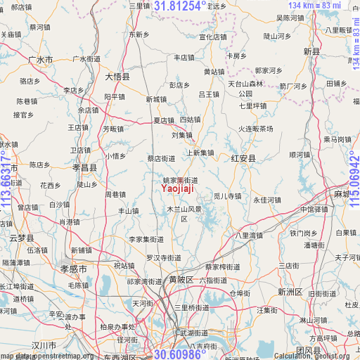
Yaojiaji GPS coordinates[2]
31° 12' 47.196" North, 114° 21' 58.644" East
| Map corner | latitude | longitude |
|---|---|---|
| Upper-left | 31.81254°, | 113.66317° |
| Center: | 31.21311°, | 114.36629° |
| Lower-right: | 30.60986°, | 115.06942° |
| Map W x H: | 133.7×133.7 km | = 83.1×83.1mi |
| max Lat: | 53.31946° ⇑43.6% North |
| Yaojiaji: | 31.21311° |
| min Lat: | ⇓56.4% South 18.22056° |
| min Long | Yaojiaji | max Long |
| 75.07348° | 114.36629° | 134.28917° |
| W 50.8%⇐ | ⇒49.2% E |
Elevation
Elevation of Yaojiaji is 54 m = 177 ft, and this is 430.8 m = 1413 ft below average elevation for this country.
| Max E: |
5622 m = 18445 ft | 69.5% |
| Avg. | 484.8 m = 1591 ft | |
| Yaojiaji | 54 m = 177 ft | |
Min E: |
-3 m = -10 ft | 30.5% |
See also: China elevation on elevation.city.
Geographical zone
Yaojiaji is located in North temperate zone (between Tropic of Cancer and the Arctic Circle). Distance of this Northern Tropic circle is 864.7 km =537.3 mi to South.| Distance of | km | miles | from Yaojiaji |
|---|---|---|---|
| North Pole | 6536.5 | 4061.6 | to North |
| Arctic Circle | 3930.6 | 2442.4 | to North |
| Tropic Cancer | 864.7 | 537.3 | to South |
| Equator | 3470.6 | 2156.5 | to South |


Nearby cities:
15 places around Yaojiaji: (largest is in red/bold)
• Caidian
11.4 km =7.1 mi,  321°
321°
• Changxuanling
13.2 km =8.2 mi,  188°
188°
• Ercheng
15.3 km =9.5 mi,  54°
54°
• Fengshan
22.4 km =13.9 mi,  239°
239°
• Gaoqiao
18.9 km =11.7 mi,  93°
93°
• Hekou
13.2 km =8.2 mi,  28°
28°
• Lijiaji
24.9 km =15.5 mi,  210°
210°
• Liuji
17.3 km =10.7 mi,  1°
1°
• Mi’ersi
25.3 km =15.7 mi,  140°
140°
• Mulan
15.2 km =9.4 mi,  146°
146°
• Shangxinji
13 km =8.1 mi, 31°
• Sigu
23 km =14.3 mi,  8°
8°
• Xiadian
23.6 km =14.7 mi,  343°
343°
• Xinghua
25.7 km =16 mi,  72°
72°
• Zhouxiang
24.6 km =15.3 mi,  258°
258°
Sources, notices
• [Note1] Compared only with cities in China existing in our database
• [Src1] Map data: © OpenStreetMap contributors (CC-BY-SA)
• [Src2] Other city data from geonames.org with taken over terms of usage.
• [Src3] Geographical zone / Annual Mean Temperature by Robert A. Rohde @ Wikipedia
