Huangpi geodata
Huangpi (Hubei) is a seat of a third-order administrative division; located in China in Asia/Shanghai (GMT+8) time zone. With population of 57,554 people, there are 761 cities with bigger population in this country. Compared to other cities in China, 53.7% of cities are located further ↓South; 50.8% of cities are located further ←West and 78.8% of cities have higher elevation than Huangpi. Note1


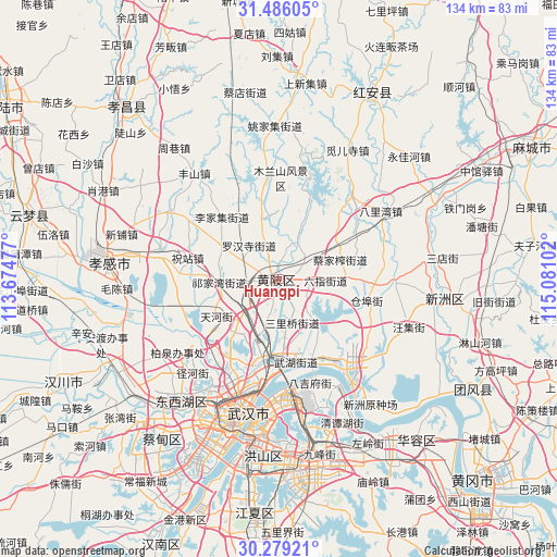
Huangpi GPS coordinates[2]
30° 53' 4.308" North, 114° 22' 40.404" East
| Map corner | latitude | longitude |
|---|---|---|
| Upper-left | 31.48605°, | 113.67477° |
| Center: | 30.88453°, | 114.37789° |
| Lower-right: | 30.27921°, | 115.08102° |
| Map W x H: | 134.2×134.2 km | = 83.4×83.4mi |
| max Lat: | 53.31946° ⇑46.3% North |
| Huangpi: | 30.88453° |
| min Lat: | ⇓53.7% South 18.22056° |
| min Long | Huangpi | max Long |
| 75.07348° | 114.37789° | 134.28917° |
| W 50.8%⇐ | ⇒49.2% E |
Elevation
Elevation of Huangpi is 29 m = 95 ft, and this is 455.8 m = 1495 ft below average elevation for this country.
| Max E: |
5622 m = 18445 ft | 78.8% |
| Avg. | 484.8 m = 1591 ft | |
| Huangpi | 29 m = 95 ft | |
Min E: |
-3 m = -10 ft | 21.2% |
See also: Huangpi elevation on elevation.city.
Geographical zone
Huangpi is located in North temperate zone (between Tropic of Cancer and the Arctic Circle). Distance of this Northern Tropic circle is 828.1 km =514.6 mi to South.| Distance of | km | miles | from Huangpi |
|---|---|---|---|
| North Pole | 6573 | 4084.3 | to North |
| Arctic Circle | 3967.1 | 2465 | to North |
| Tropic Cancer | 828.1 | 514.6 | to South |
| Equator | 3434 | 2133.8 | to South |


Nearby cities:
15 places around Huangpi: (largest is in red/bold)
• Caijiazha
15.3 km =9.5 mi,  72°
72°
• Cangbu
21.3 km =13.2 mi,  105°
105°
• Changxuanling
23.7 km =14.7 mi,  352°
352°
• Hengdian
12.1 km =7.5 mi,  223°
223°
• Jiaomingsi
11.7 km =7.3 mi,  164°
164°
• Lijiaji
20.5 km =12.7 mi,  317°
317°
• Liuzhi
11.2 km =7 mi,  90°
90°
• Mi’ersi
22.7 km =14.1 mi,  41°
41°
• Qianquan
1.6 km =1 mi,  198°
198°
• Shekou
19.2 km =11.9 mi,  188°
188°
• Tianhe
18 km =11.2 mi,  240°
240°
• Wangjiahe
9.4 km =5.8 mi,  20°
20°
• Wutongkou
21.5 km =13.4 mi,  173°
173°
• Zhanjiaji
24.1 km =15 mi, 185°
• Zhuzhan
21.8 km =13.5 mi,  282°
282°
Sources, notices
• [Note1] Compared only with cities in China existing in our database
• [Src1] Map data: © OpenStreetMap contributors (CC-BY-SA)
• [Src2] Other city data from geonames.org with taken over terms of usage.
• [Src3] Geographical zone / Annual Mean Temperature by Robert A. Rohde @ Wikipedia
