Mengbi geodata
Mengbi (Hunan) is a seat of a fourth-order administrative division; located in China in Asia/Shanghai (GMT+8) time zone. In our database, there are 1268 cities with bigger population. Compared to other cities in China, 61% of cities are located further ↑North; 72.3% of cities are located further →East and 80.2% of cities have lower elevation than Mengbi. Note1


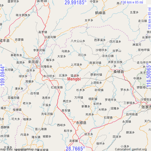
Mengbi GPS coordinates[2]
29° 22' 51.672" North, 109° 47' 51.072" East
| Map corner | latitude | longitude |
|---|---|---|
| Upper-left | 29.99185°, | 109.0944° |
| Center: | 29.38102°, | 109.79752° |
| Lower-right: | 28.7665°, | 110.50065° |
| Map W x H: | 136.2×136.2 km | = 84.6×84.6mi |
| max Lat: | 53.31946° ⇑61% North |
| Mengbi: | 29.38102° |
| min Lat: | ⇓39% South 18.22056° |
| min Long | Mengbi | max Long |
| 75.07348° | 109.79752° | 134.28917° |
| W 27.7%⇐ | ⇒72.3% E |
Elevation
Elevation of Mengbi is 706 m = 2316 ft, and this is 221.2 m = 726 ft above average elevation for this country.
| Max E: |
5622 m = 18445 ft | 19.8% |
| Mengbi | 706 m 2316 ft | |
| Avg. | 484.8 m = 1591 ft | |
Min E: |
-3 m = -10 ft | 80.2% |
See also: China elevation on elevation.city.
Geographical zone
Mengbi is located in North temperate zone (between Tropic of Cancer and the Arctic Circle). Distance of this Northern Tropic circle is 660.9 km =410.7 mi to South.| Distance of | km | miles | from Mengbi |
|---|---|---|---|
| North Pole | 6740.2 | 4188.2 | to North |
| Arctic Circle | 4134.3 | 2568.9 | to North |
| Tropic Cancer | 660.9 | 410.7 | to South |
| Equator | 3266.9 | 2030 | to South |


Nearby cities:
15 places around Mengbi: (largest is in red/bold)
• Bixidong
10.6 km =6.6 mi,  271°
271°
• Ciyantang
19.9 km =12.4 mi,  280°
280°
• Guanba
18.9 km =11.7 mi,  120°
120°
• Hongyanxi
19.2 km =11.9 mi,  236°
236°
• Maoba
14.9 km =9.3 mi,  144°
144°
• Miaojia
19.2 km =11.9 mi,  86°
86°
• Pailou
19.6 km =12.2 mi,  17°
17°
• Ruchihe
12.4 km =7.7 mi,  220°
220°
• Shangdongjie
19.3 km =12 mi,  107°
107°
• Shanghexi
10.5 km =6.5 mi,  2°
2°
• Shanmu
13.6 km =8.5 mi,  159°
159°
• Shuitianba
10.9 km =6.8 mi,  316°
316°
• Wanmingang
12.2 km =7.6 mi,  75°
75°
• Xinchang
15.1 km =9.4 mi,  205°
205°
• Yanwukou
17.7 km =11 mi,  40°
40°
Sources, notices
• [Note1] Compared only with cities in China existing in our database
• [Src1] Map data: © OpenStreetMap contributors (CC-BY-SA)
• [Src2] Other city data from geonames.org with taken over terms of usage.
• [Src3] Geographical zone / Annual Mean Temperature by Robert A. Rohde @ Wikipedia
