Pailou geodata
Pailou (Hunan) is a seat of a fourth-order administrative division; located in China in Asia/Shanghai (GMT+8) time zone. In our database, there are 1268 cities with bigger population. Compared to other cities in China, 59.2% of cities are located further ↑North; 71.9% of cities are located further →East and 73% of cities have lower elevation than Pailou. Note1


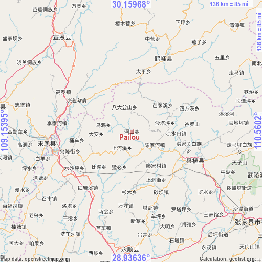
Pailou GPS coordinates[2]
29° 32' 59.532" North, 109° 51' 25.452" East
| Map corner | latitude | longitude |
|---|---|---|
| Upper-left | 30.15968°, | 109.15395° |
| Center: | 29.54987°, | 109.85707° |
| Lower-right: | 28.93636°, | 110.5602° |
| Map W x H: | 136×136 km | = 84.5×84.5mi |
| max Lat: | 53.31946° ⇑59.2% North |
| Pailou: | 29.54987° |
| min Lat: | ⇓40.8% South 18.22056° |
| min Long | Pailou | max Long |
| 75.07348° | 109.85707° | 134.28917° |
| W 28.1%⇐ | ⇒71.9% E |
Elevation
Elevation of Pailou is 476 m = 1562 ft, and this is 8.8 m = 29 ft below average elevation for this country.
| Max E: |
5622 m = 18445 ft | 27% |
| Avg. | 484.8 m = 1591 ft | |
| Pailou | 476 m = 1562 ft | |
Min E: |
-3 m = -10 ft | 73% |
See also: China elevation on elevation.city.
Geographical zone
Pailou is located in North temperate zone (between Tropic of Cancer and the Arctic Circle). Distance of this Northern Tropic circle is 679.7 km =422.3 mi to South.| Distance of | km | miles | from Pailou |
|---|---|---|---|
| North Pole | 6721.4 | 4176.5 | to North |
| Arctic Circle | 4115.5 | 2557.3 | to North |
| Tropic Cancer | 679.7 | 422.3 | to South |
| Equator | 3285.6 | 2041.6 | to South |


Nearby cities:
15 places around Pailou: (largest is in red/bold)
• Bamaoxi
21.3 km =13.2 mi,  49°
49°
• Chenjiahe
13.6 km =8.5 mi,  121°
121°
• Da’anping
18 km =11.2 mi,  265°
265°
• Jianjiapo
9.5 km =5.9 mi,  88°
88°
• Lianghekou
19.6 km =12.2 mi, 123°
• Mengbi
19.6 km =12.2 mi,  197°
197°
• Miaojia
22.2 km =13.8 mi,  143°
143°
• Shadiping
13.2 km =8.2 mi,  344°
344°
• Shanghexi
9.8 km =6.1 mi,  212°
212°
• Shataping
18.1 km =11.2 mi,  76°
76°
• Shuitianba
17.1 km =10.6 mi,  230°
230°
• Wangjiaping
17.9 km =11.1 mi,  17°
17°
• Wanmingang
16.9 km =10.5 mi,  159°
159°
• Wuyahe
14.3 km =8.9 mi,  281°
281°
• Yanwukou
7.9 km =4.9 mi,  133°
133°
Sources, notices
• [Note1] Compared only with cities in China existing in our database
• [Src1] Map data: © OpenStreetMap contributors (CC-BY-SA)
• [Src2] Other city data from geonames.org with taken over terms of usage.
• [Src3] Geographical zone / Annual Mean Temperature by Robert A. Rohde @ Wikipedia
