Yanwukou geodata
Yanwukou (Hunan) is a seat of a fourth-order administrative division; located in China in Asia/Shanghai (GMT+8) time zone. In our database, there are 1268 cities with bigger population. Compared to other cities in China, 59.7% of cities are located further ↑North; 71.7% of cities are located further →East and 66.5% of cities have lower elevation than Yanwukou. Note1


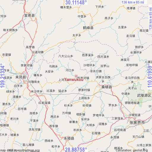
Yanwukou GPS coordinates[2]
29° 30' 4.968" North, 109° 54' 59.256" East
| Map corner | latitude | longitude |
|---|---|---|
| Upper-left | 30.11148°, | 109.21334° |
| Center: | 29.50138°, | 109.91646° |
| Lower-right: | 28.88758°, | 110.61959° |
| Map W x H: | 136.1×136.1 km | = 84.6×84.6mi |
| max Lat: | 53.31946° ⇑59.7% North |
| Yanwukou: | 29.50138° |
| min Lat: | ⇓40.3% South 18.22056° |
| min Long | Yanwukou | max Long |
| 75.07348° | 109.91646° | 134.28917° |
| W 28.3%⇐ | ⇒71.7% E |
Elevation
Elevation of Yanwukou is 352 m = 1155 ft, and this is 132.8 m = 436 ft below average elevation for this country.
| Max E: |
5622 m = 18445 ft | 33.5% |
| Avg. | 484.8 m = 1591 ft | |
| Yanwukou | 352 m = 1155 ft | |
Min E: |
-3 m = -10 ft | 66.5% |
See also: China elevation on elevation.city.
Geographical zone
Yanwukou is located in North temperate zone (between Tropic of Cancer and the Arctic Circle). Distance of this Northern Tropic circle is 674.3 km =419 mi to South.| Distance of | km | miles | from Yanwukou |
|---|---|---|---|
| North Pole | 6726.8 | 4179.8 | to North |
| Arctic Circle | 4120.9 | 2560.6 | to North |
| Tropic Cancer | 674.3 | 419 | to South |
| Equator | 3280.2 | 2038.2 | to South |


Nearby cities:
15 places around Yanwukou: (largest is in red/bold)
• Chenjiahe
6.1 km =3.8 mi,  106°
106°
• Jianjiapo
6.9 km =4.3 mi,  33°
33°
• Lianghekou
11.9 km =7.4 mi,  117°
117°
• Liangshuikou
18 km =11.2 mi,  75°
75°
• Mengbi
17.7 km =11 mi,  220°
220°
• Miaojia
14.5 km =9 mi,  148°
148°
• Pailou
7.9 km =4.9 mi,  313°
313°
• Shadiping
20.4 km =12.7 mi,  333°
333°
• Shangdongjie
20.3 km =12.6 mi,  160°
160°
• Shanghexi
11.4 km =7.1 mi,  255°
255°
• Shataping
15.3 km =9.5 mi,  50°
50°
• Shuitianba
19.7 km =12.2 mi,  254°
254°
• Wanmingang
10.4 km =6.5 mi,  178°
178°
• Wuyahe
21.4 km =13.3 mi,  292°
292°
• Xiaobutou
18.1 km =11.2 mi,  104°
104°
Sources, notices
• [Note1] Compared only with cities in China existing in our database
• [Src1] Map data: © OpenStreetMap contributors (CC-BY-SA)
• [Src2] Other city data from geonames.org with taken over terms of usage.
• [Src3] Geographical zone / Annual Mean Temperature by Robert A. Rohde @ Wikipedia
