Shangdongjie geodata
Shangdongjie (Hunan) is a seat of a fourth-order administrative division; located in China in Asia/Shanghai (GMT+8) time zone. In our database, there are 1268 cities with bigger population. Compared to other cities in China, 61.6% of cities are located further ↑North; 71.3% of cities are located further →East and 68.5% of cities have lower elevation than Shangdongjie. Note1


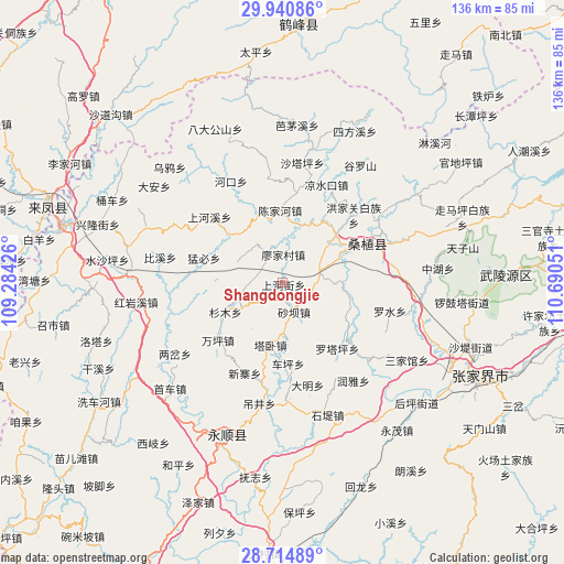
Shangdongjie GPS coordinates[2]
29° 19' 46.992" North, 109° 59' 14.568" East
| Map corner | latitude | longitude |
|---|---|---|
| Upper-left | 29.94086°, | 109.28426° |
| Center: | 29.32972°, | 109.98738° |
| Lower-right: | 28.71489°, | 110.69051° |
| Map W x H: | 136.3×136.3 km | = 84.7×84.7mi |
| max Lat: | 53.31946° ⇑61.6% North |
| Shangdongjie: | 29.32972° |
| min Lat: | ⇓38.4% South 18.22056° |
| min Long | Shangdongjie | max Long |
| 75.07348° | 109.98738° | 134.28917° |
| W 28.7%⇐ | ⇒71.3% E |
Elevation
Elevation of Shangdongjie is 385 m = 1263 ft, and this is 99.8 m = 327 ft below average elevation for this country.
| Max E: |
5622 m = 18445 ft | 31.5% |
| Avg. | 484.8 m = 1591 ft | |
| Shangdongjie | 385 m = 1263 ft | |
Min E: |
-3 m = -10 ft | 68.5% |
See also: China elevation on elevation.city.
Geographical zone
Shangdongjie is located in North temperate zone (between Tropic of Cancer and the Arctic Circle). Distance of this Northern Tropic circle is 655.2 km =407.1 mi to South.| Distance of | km | miles | from Shangdongjie |
|---|---|---|---|
| North Pole | 6745.9 | 4191.7 | to North |
| Arctic Circle | 4140 | 2572.5 | to North |
| Tropic Cancer | 655.2 | 407.1 | to South |
| Equator | 3261.2 | 2026.4 | to South |


Nearby cities:
15 places around Shangdongjie: (largest is in red/bold)
• Chenjiahe
17.4 km =10.8 mi,  356°
356°
• Guanba
4.4 km =2.7 mi,  208°
208°
• Guancangping
17.7 km =11 mi,  202°
202°
• Lianghekou
14.1 km =8.8 mi,  15°
15°
• Lifuta
8.6 km =5.3 mi,  79°
79°
• Liyuan
17.9 km =11.1 mi,  65°
65°
• Maoba
11.6 km =7.2 mi,  236°
236°
• Miaojia
6.8 km =4.2 mi,  6°
6°
• Qing’anping
17.1 km =10.6 mi,  108°
108°
• Shaba
7.6 km =4.7 mi,  157°
157°
• Shanmu
15.4 km =9.6 mi, 242°
• Taozixi
6.9 km =4.3 mi, 110°
• Tawo
15.3 km =9.5 mi,  190°
190°
• Wanmingang
10.9 km =6.8 mi,  322°
322°
• Xiangjiazhai
13.8 km =8.6 mi,  172°
172°
Sources, notices
• [Note1] Compared only with cities in China existing in our database
• [Src1] Map data: © OpenStreetMap contributors (CC-BY-SA)
• [Src2] Other city data from geonames.org with taken over terms of usage.
• [Src3] Geographical zone / Annual Mean Temperature by Robert A. Rohde @ Wikipedia
