Ehu geodata
Ehu (Jiangsu) is a seat of a fourth-order administrative division; located in China in Asia/Shanghai (GMT+8) time zone. In our database, there are 1268 cities with bigger population. Compared to other cities in China, 58.6% of cities are located further ↓South; 85.3% of cities are located further ←West and 95.9% of cities have higher elevation than Ehu. Note1


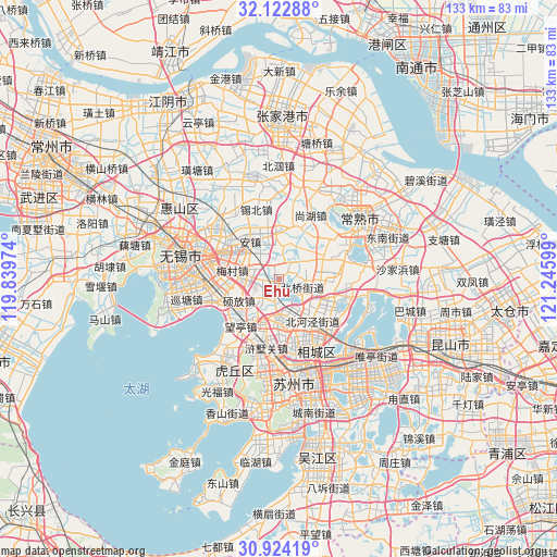
Ehu GPS coordinates[2]
31° 31' 31.656" North, 120° 32' 34.296" East
| Map corner | latitude | longitude |
|---|---|---|
| Upper-left | 32.12288°, | 119.83974° |
| Center: | 31.52546°, | 120.54286° |
| Lower-right: | 30.92419°, | 121.24599° |
| Map W x H: | 133.3×133.3 km | = 82.8×82.8mi |
| max Lat: | 53.31946° ⇑41.4% North |
| Ehu: | 31.52546° |
| min Lat: | ⇓58.6% South 18.22056° |
| min Long | Ehu | max Long |
| 75.07348° | 120.54286° | 134.28917° |
| W 85.3%⇐ | ⇒14.7% E |
Elevation
Elevation of Ehu is 6 m = 20 ft, and this is 478.8 m = 1571 ft below average elevation for this country.
| Max E: |
5622 m = 18445 ft | 95.9% |
| Avg. | 484.8 m = 1591 ft | |
| Ehu | 6 m = 20 ft | |
Min E: |
-3 m = -10 ft | 4.1% |
See also: China elevation on elevation.city.
Geographical zone
Ehu is located in North temperate zone (between Tropic of Cancer and the Arctic Circle). Distance of this Northern Tropic circle is 899.4 km =558.9 mi to South.| Distance of | km | miles | from Ehu |
|---|---|---|---|
| North Pole | 6501.8 | 4040 | to North |
| Arctic Circle | 3895.9 | 2420.8 | to North |
| Tropic Cancer | 899.4 | 558.9 | to South |
| Equator | 3505.3 | 2178.1 | to South |


Nearby cities:
15 places around Ehu: (largest is in red/bold)
• Anzhen
11.7 km =7.3 mi,  323°
323°
• Beiqiao
5.3 km =3.3 mi,  110°
110°
• Fangqian
15.8 km =9.8 mi,  282°
282°
• Hongshan
6.6 km =4.1 mi,  227°
227°
• Huangdai
10 km =6.2 mi,  172°
172°
• Meicun
10.9 km =6.8 mi, 282°
• Shuofang
10.6 km =6.6 mi,  247°
247°
• Taiping
17.8 km =11.1 mi,  124°
124°
• Wangting
13.5 km =8.4 mi, 225°
• Weitang
11.8 km =7.3 mi, 124°
• Xinzhuang
13.9 km =8.6 mi,  84°
84°
• Xushuguan
16.7 km =10.4 mi,  194°
194°
• Yangdenghu
17.5 km =10.9 mi,  101°
101°
• Yangjian
11.5 km =7.1 mi,  5°
5°
• Yuanhe
15.6 km =9.7 mi,  154°
154°
Sources, notices
• [Note1] Compared only with cities in China existing in our database
• [Src1] Map data: © OpenStreetMap contributors (CC-BY-SA)
• [Src2] Other city data from geonames.org with taken over terms of usage.
• [Src3] Geographical zone / Annual Mean Temperature by Robert A. Rohde @ Wikipedia
