Luancheng geodata
Luancheng (Hebei) is a populated place; located in China in Asia/Shanghai (GMT+8) time zone. With population of 597,130 people, there are 110 cities with bigger population in this country. Compared to other cities in China, 80.7% of cities are located further ↓South; 52.4% of cities are located further ←West and 69.2% of cities have higher elevation than Luancheng. Note1


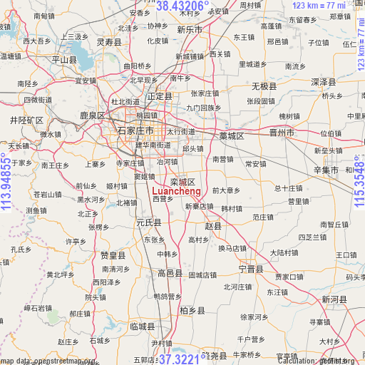
Luancheng GPS coordinates[2]
37° 52' 45.012" North, 114° 39' 6.012" East
| Map corner | latitude | longitude |
|---|---|---|
| Upper-left | 38.43206°, | 113.94855° |
| Center: | 37.87917°, | 114.65167° |
| Lower-right: | 37.3221°, | 115.3548° |
| Map W x H: | 123.4×123.4 km | = 76.7×76.7mi |
| max Lat: | 53.31946° ⇑19.3% North |
| Luancheng: | 37.87917° |
| min Lat: | ⇓80.7% South 18.22056° |
| min Long | Luancheng | max Long |
| 75.07348° | 114.65167° | 134.28917° |
| W 52.4%⇐ | ⇒47.6% E |
Elevation
Elevation of Luancheng is 55 m = 180 ft, and this is 429.8 m = 1410 ft below average elevation for this country.
| Max E: |
5622 m = 18445 ft | 69.2% |
| Avg. | 484.8 m = 1591 ft | |
| Luancheng | 55 m = 180 ft | |
Min E: |
-3 m = -10 ft | 30.8% |
See also: Luancheng elevation on elevation.city.
Geographical zone
Luancheng is located in North temperate zone (between Tropic of Cancer and the Arctic Circle). Distance of this Northern Tropic circle is 1605.8 km =997.8 mi to South.| Distance of | km | miles | from Luancheng |
|---|---|---|---|
| North Pole | 5795.3 | 3601 | to North |
| Arctic Circle | 3189.4 | 1981.8 | to North |
| Tropic Cancer | 1605.8 | 997.8 | to South |
| Equator | 4211.8 | 2617.1 | to South |


Nearby cities:
15 places around Luancheng: (largest is in red/bold)
• Beile
14 km =8.7 mi,  2°
2°
• Ershilipu
18.4 km =11.4 mi,  338°
338°
• Gangshang
18.9 km =11.7 mi,  9°
9°
• Haozhuang
27.7 km =17.2 mi,  36°
36°
• Jiumen
26.3 km =16.3 mi,  15°
15°
• Liuying
27.9 km =17.3 mi,  313°
313°
• Nancun
20.4 km =12.7 mi,  356°
356°
• Nandong
26.6 km =16.5 mi, 20°
• Shangzhuang
29.9 km =18.6 mi,  304°
304°
• Shijiazhuang
23.6 km =14.7 mi,  319°
319°
• Songying
16.5 km =10.3 mi,  352°
352°
• Taoyuan
25.5 km =15.8 mi,  332°
332°
• Xing’an
27.6 km =17.1 mi,  56°
56°
• Xizhaotong
21.9 km =13.6 mi, 347°
• Zhaolingpu
29.4 km =18.3 mi, 326°
Sources, notices
• [Note1] Compared only with cities in China existing in our database
• [Src1] Map data: © OpenStreetMap contributors (CC-BY-SA)
• [Src2] Other city data from geonames.org with taken over terms of usage.
• [Src3] Geographical zone / Annual Mean Temperature by Robert A. Rohde @ Wikipedia
