Longyuanba geodata
Longyuanba (Jiangxi) is a seat of a fourth-order administrative division; located in China in Asia/Shanghai (GMT+8) time zone. In our database, there are 1268 cities with bigger population. Compared to other cities in China, 86.6% of cities are located further ↑North; 51.3% of cities are located further ←West and 59.2% of cities have lower elevation than Longyuanba. Note1


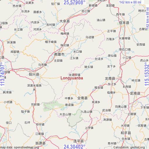
Longyuanba GPS coordinates[2]
24° 56' 35.52" North, 114° 27' 0.684" East
| Map corner | latitude | longitude |
|---|---|---|
| Upper-left | 25.57908°, | 113.74707° |
| Center: | 24.9432°, | 114.45019° |
| Lower-right: | 24.30402°, | 115.15332° |
| Map W x H: | 141.8×141.8 km | = 88.1×88.1mi |
| max Lat: | 53.31946° ⇑86.6% North |
| Longyuanba: | 24.9432° |
| min Lat: | ⇓13.4% South 18.22056° |
| min Long | Longyuanba | max Long |
| 75.07348° | 114.45019° | 134.28917° |
| W 51.3%⇐ | ⇒48.7% E |
Elevation
Elevation of Longyuanba is 250 m = 820 ft, and this is 234.8 m = 770 ft below average elevation for this country.
| Max E: |
5622 m = 18445 ft | 40.8% |
| Avg. | 484.8 m = 1591 ft | |
| Longyuanba | 250 m = 820 ft | |
Min E: |
-3 m = -10 ft | 59.2% |
See also: China elevation on elevation.city.
Geographical zone
Longyuanba is located in North temperate zone (between Tropic of Cancer and the Arctic Circle). Distance of this Northern Tropic circle is 167.5 km =104.1 mi to South.| Distance of | km | miles | from Longyuanba |
|---|---|---|---|
| North Pole | 7233.6 | 4494.7 | to North |
| Arctic Circle | 4627.8 | 2875.6 | to North |
| Tropic Cancer | 167.5 | 104.1 | to South |
| Equator | 2773.4 | 1723.3 | to South |


Nearby cities:
15 places around Longyuanba: (largest is in red/bold)
• Beitou
14.8 km =9.2 mi,  64°
64°
• Chengjiang
11.9 km =7.4 mi,  256°
256°
• Chenglong
25.9 km =16.1 mi,  118°
118°
• Duheng
26.2 km =16.3 mi,  222°
222°
• Dujiang
26.6 km =16.5 mi,  108°
108°
• Gushi
23.9 km =14.9 mi,  301°
301°
• Hukou
26 km =16.2 mi,  349°
349°
• Jiangtou
15.9 km =9.9 mi,  358°
358°
• Jinlong
23 km =14.3 mi,  158°
158°
• Luoba
25.6 km =15.9 mi,  250°
250°
• Nanmu
26.5 km =16.5 mi,  23°
23°
• Shuikou
22.3 km =13.9 mi,  7°
7°
• Xiongzhou
24.5 km =15.2 mi,  321°
321°
• Zhongzhai
23 km =14.3 mi,  193°
193°
• Zhutian
20.6 km =12.8 mi,  311°
311°
Sources, notices
• [Note1] Compared only with cities in China existing in our database
• [Src1] Map data: © OpenStreetMap contributors (CC-BY-SA)
• [Src2] Other city data from geonames.org with taken over terms of usage.
• [Src3] Geographical zone / Annual Mean Temperature by Robert A. Rohde @ Wikipedia
