Licheng geodata
Licheng (Jiangsu) is a seat of a third-order administrative division; located in China in Asia/Shanghai (GMT+8) time zone. With population of 72,276 people, there are 595 cities with bigger population in this country. Compared to other cities in China, 57.9% of cities are located further ↓South; 78.7% of cities are located further ←West and 91.2% of cities have higher elevation than Licheng. Note1


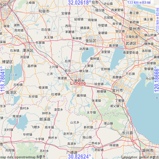
Licheng GPS coordinates[2]
31° 25' 41.268" North, 119° 29' 0.708" East
| Map corner | latitude | longitude |
|---|---|---|
| Upper-left | 32.02618°, | 118.78041° |
| Center: | 31.42813°, | 119.48353° |
| Lower-right: | 30.82624°, | 120.18666° |
| Map W x H: | 133.4×133.4 km | = 82.9×82.9mi |
| max Lat: | 53.31946° ⇑42.1% North |
| Licheng: | 31.42813° |
| min Lat: | ⇓57.9% South 18.22056° |
| min Long | Licheng | max Long |
| 75.07348° | 119.48353° | 134.28917° |
| W 78.7%⇐ | ⇒21.3% E |
Elevation
Elevation of Licheng is 9 m = 30 ft, and this is 475.8 m = 1561 ft below average elevation for this country.
| Max E: |
5622 m = 18445 ft | 91.2% |
| Avg. | 484.8 m = 1591 ft | |
| Licheng | 9 m = 30 ft | |
Min E: |
-3 m = -10 ft | 8.8% |
See also: Licheng elevation on elevation.city.
Geographical zone
Licheng is located in North temperate zone (between Tropic of Cancer and the Arctic Circle). Distance of this Northern Tropic circle is 888.6 km =552.2 mi to South.| Distance of | km | miles | from Licheng |
|---|---|---|---|
| North Pole | 6512.6 | 4046.7 | to North |
| Arctic Circle | 3906.7 | 2427.5 | to North |
| Tropic Cancer | 888.6 | 552.2 | to South |
| Equator | 3494.5 | 2171.4 | to South |


Nearby cities:
15 places around Licheng: (largest is in red/bold)
• Bieqiao
14.6 km =9.1 mi,  351°
351°
• Daibu
13.1 km =8.1 mi,  174°
174°
• Daitou
8.2 km =5.1 mi,  23°
23°
• Hutang
11.8 km =7.3 mi,  2°
2°
• Nandu
10.5 km =6.5 mi,  269°
269°
• Nandu
14.7 km =9.1 mi,  275°
275°
• Shanghuang
15.2 km =9.4 mi,  30°
30°
• Shangxing
20.8 km =12.9 mi,  295°
295°
• Shezhu
20.7 km =12.9 mi,  232°
232°
• Tianmuhu
12.1 km =7.5 mi,  200°
200°
• Xizhu
17.4 km =10.8 mi,  152°
152°
• Xushe
16.3 km =10.1 mi,  102°
102°
• Yangxiang
11.3 km =7 mi,  60°
60°
• Zhoucheng
14.4 km =8.9 mi, 229°
• Zhuze
18.5 km =11.5 mi,  320°
320°
Sources, notices
• [Note1] Compared only with cities in China existing in our database
• [Src1] Map data: © OpenStreetMap contributors (CC-BY-SA)
• [Src2] Other city data from geonames.org with taken over terms of usage.
• [Src3] Geographical zone / Annual Mean Temperature by Robert A. Rohde @ Wikipedia
