Xushe geodata
Xushe (Jiangsu) is a seat of a fourth-order administrative division; located in China in Asia/Shanghai (GMT+8) time zone. In our database, there are 1268 cities with bigger population. Compared to other cities in China, 57.7% of cities are located further ↓South; 79.7% of cities are located further ←West and 95.9% of cities have higher elevation than Xushe. Note1


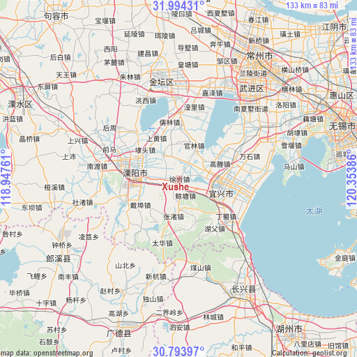
Xushe GPS coordinates[2]
31° 23' 45.816" North, 119° 39' 2.628" East
| Map corner | latitude | longitude |
|---|---|---|
| Upper-left | 31.99431°, | 118.94761° |
| Center: | 31.39606°, | 119.65073° |
| Lower-right: | 30.79397°, | 120.35386° |
| Map W x H: | 133.5×133.5 km | = 83×83mi |
| max Lat: | 53.31946° ⇑42.3% North |
| Xushe: | 31.39606° |
| min Lat: | ⇓57.7% South 18.22056° |
| min Long | Xushe | max Long |
| 75.07348° | 119.65073° | 134.28917° |
| W 79.7%⇐ | ⇒20.3% E |
Elevation
Elevation of Xushe is 6 m = 20 ft, and this is 478.8 m = 1571 ft below average elevation for this country.
| Max E: |
5622 m = 18445 ft | 95.9% |
| Avg. | 484.8 m = 1591 ft | |
| Xushe | 6 m = 20 ft | |
Min E: |
-3 m = -10 ft | 4.1% |
See also: China elevation on elevation.city.
Geographical zone
Xushe is located in North temperate zone (between Tropic of Cancer and the Arctic Circle). Distance of this Northern Tropic circle is 885 km =549.9 mi to South.| Distance of | km | miles | from Xushe |
|---|---|---|---|
| North Pole | 6516.1 | 4048.9 | to North |
| Arctic Circle | 3910.3 | 2429.7 | to North |
| Tropic Cancer | 885 | 549.9 | to South |
| Equator | 3490.9 | 2169.1 | to South |


Nearby cities:
15 places around Xushe: (largest is in red/bold)
• Daibu
17.4 km =10.8 mi,  237°
237°
• Daitou
16.8 km =10.4 mi,  311°
311°
• Gaocheng
16.2 km =10.1 mi,  65°
65°
• Guanlin
13.3 km =8.3 mi,  25°
25°
• Liangpeng
21.5 km =13.4 mi, 25°
• Licheng
16.3 km =10.1 mi,  282°
282°
• Qiting
20.4 km =12.7 mi,  77°
77°
• Shanghuang
18.5 km =11.5 mi,  333°
333°
• Tianmuhu
21.6 km =13.4 mi,  248°
248°
• Xinjian
18.4 km =11.4 mi,  1°
1°
• Xinjie
9.8 km =6.1 mi,  107°
107°
• Xizhu
14.3 km =8.9 mi,  213°
213°
• Yangxiang
10.9 km =6.8 mi, 326°
• Yicheng
16.6 km =10.3 mi,  103°
103°
• Zhangzhu
14.4 km =8.9 mi,  188°
188°
Sources, notices
• [Note1] Compared only with cities in China existing in our database
• [Src1] Map data: © OpenStreetMap contributors (CC-BY-SA)
• [Src2] Other city data from geonames.org with taken over terms of usage.
• [Src3] Geographical zone / Annual Mean Temperature by Robert A. Rohde @ Wikipedia
